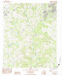
1983 Map of Simpsonville
USGS Topo · Published 1983About this map
The Reedy River meanders southward through this 1983 Greenville County landscape, serving as a central geographic anchor for a region in transition. Around Simpsonville, the presence of the Seaboard railroad and several industrial facilities, including various sewage disposal ponds, indicates the growing infrastructure of the late twentieth century. Despite this modernization, the map preserves a dense network of local landmarks essential for genealogical research, including multiple country churches like Antioch Ch and Hopewell Ch, and historic burial grounds such as Fellowship Cem and Cureton Cem.
Find a feature on this map
30 named features on this map. Tap any name to fly to it.
Don’t see what you’re looking for? This feature index may not catch every label — zoom into the map to look around manually.
Map Details
Editions of this 1983 Simpsonville Map
2 editions found
Other maps of this area

1935 · Greer
USGS Topo · 1:48,000

1935 · Greenville
USGS Topo · 1:48,000

1938 · Greenville
USGS Topo · 1:62,500

1938 · Greer
USGS Topo · 1:62,500

1954 · Greenville
USGS Topo · 1:250,000

1957 · Fountain Inn
USGS Topo · 1:62,500

1957 · Greenville
USGS Topo · 1:24,000

1957 · Williamston
USGS Topo · 1:62,500

1957 · Greer
USGS Topo · 1:62,500

1957 · Greenville
USGS Topo · 1:62,500
Featured Places
- Mauldin, SC
- Simpsonville, SC
- Cherokee Heights, Simpsonville
- Westwood, Simpsonville
- Greenville County, SC