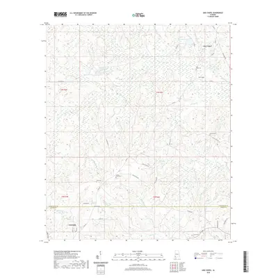
2020 Map of Sims Chapel
USGS Topo · Published 2020About this map
Sims Chapel and the outskirts of Citronelle define this portion of the Alabama coastal plain along the Washington Co Mobile Co line. The landscape is characterized by a dense network of small watercourses, including Poll Bayou, Bilbo Br, and Crane Pond Br, which drain the low-lying terrain. For genealogists and local historians, the map provides precise locations for several community burial grounds such as Sims Chapel Cem, Red Wash Cem, and Charity Chapel Cem. Land use patterns are shaped by timber and water resources, evidenced by the Tensaw Land and Timber Co Pond and Best Pond. A web of rural routes like Lewis Simpson Rd and Wilmer Reid Rd connects these scattered settlements and homesteads, illustrating the enduring rural character of this southern Alabama region.
Find a feature on this map
55 named features on this map. Tap any name to fly to it.
Don’t see what you’re looking for? This feature index may not catch every label — zoom into the map to look around manually.
Map Details
Editions of this 2020 Sims Chapel Map
This is the sole edition of this map. No revisions or reprints were ever made.
Other maps of this area

1942 · Deer Park
USGS Topo · 1:62,500

1943 · Deer Park
USGS Topo · 1:62,500

1943 · Citronelle
USGS Topo · 1:62,500

1943 · McIntosh
USGS Topo · 1:62,500

1944 · McIntosh
USGS Topo · 1:62,500

1946 · Citronelle
USGS Topo · 1:62,500

1953 · Hattiesburg
USGS Topo · 1:250,000

1958 · Hattiesburg
USGS Topo · 1:250,000

1974 · Vinegar Bend
USGS Topo · 1:24,000
1982 · Citronelle West
USGS Topo · 1:24,000