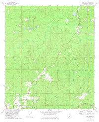
1982 Map of Sims Chapel
USGS Topo · Published 1982About this map
The border of Washington and Mobile counties runs through this landscape of the Gulf Coastal Plain in the early 1980s. The settlement at Sims Chapel sits alongside the Burlington Northern railroad, which cuts a northwest-to-southeast path through the timbered terrain. Further southwest, the community of Charity Chapel serves as a local focal point, anchored by the Charity Chapel Ch and the nearby Sawyer Cem. The land is characterized by an intricate network of waterways like Poll Bayou and Bear Creek, punctuated by industrial activity. In the southwest corner, the northern edge of Citronelle is visible, surrounded by a concentration of Oil Wells and pipelines, reflecting the region's mid-century energy development. Smaller sites like Andrews and Summit appear as rural junctions, while the Illinois Central Gulf rail line provides a secondary transit corridor through the eastern woods.
Find a feature on this map
33 named features on this map. Tap any name to fly to it.
Don’t see what you’re looking for? This feature index may not catch every label — zoom into the map to look around manually.
Map Details
Editions of this 1982 Sims Chapel Map
This is the sole edition of this map. No revisions or reprints were ever made.
Other maps of this area

1942 · Deer Park
USGS Topo · 1:62,500

1943 · Deer Park
USGS Topo · 1:62,500

1943 · Citronelle
USGS Topo · 1:62,500

1943 · McIntosh
USGS Topo · 1:62,500

1944 · McIntosh
USGS Topo · 1:62,500

1946 · Citronelle
USGS Topo · 1:62,500

1953 · Hattiesburg
USGS Topo · 1:250,000

1958 · Hattiesburg
USGS Topo · 1:250,000

1974 · Vinegar Bend
USGS Topo · 1:24,000
1982 · Citronelle West
USGS Topo · 1:24,000