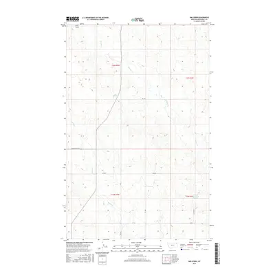
2017 Map of Sims Spring
USGS Topo · Published 2017About this map
Sims Spring sits at the heart of this Montana landscape in Roosevelt County, where the high plains terrain is defined by a network of seasonal watercourses and coulees. The map traces the winding paths of Chelsea Cr, Boxelder Cr, and Smith Coulee, illustrating the drainage patterns that have shaped ranching and land use in the Wolf Point District. Human impact on the land is visible through managed water resources like Structure Number 149 Reservoir and a grid of rural routes such as Powder River Rd and various numbered county roads. This survey provides a clear view of the Public Land Survey System divisions, marking the boundaries of t30n r48e and neighboring townships as they stood in the early 21st century.
Find a feature on this map
17 named features on this map. Tap any name to fly to it.
Don’t see what you’re looking for? This feature index may not catch every label — zoom into the map to look around manually.
Map Details
Editions of this 2017 Sims Spring Map
This is the sole edition of this map. No revisions or reprints were ever made.
Other maps of this area

1910 · Cuskers
USGS Topo · 1:62,500

1912 · Chelsea
USGS Topo · 1:62,500

1915 · Tule Valley
USGS Topo · 1:62,500

1915 · Cuskers
USGS Topo · 1:62,500

1916 · Wolf Point
USGS Topo · 1:62,500

1954 · Wolf Point
USGS Topo · 1:250,000

1958 · Wolf Point
USGS Topo · 1:250,000

1972 · Chelsea
USGS Topo · 1:24,000

1972 · Chelsea NW
USGS Topo · 1:24,000
1972 · Wolf Point NE
USGS Topo · 1:24,000