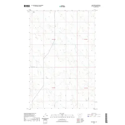
2020 Map of Sims Spring
USGS Topo · Published 2020About this map
Sims Spring and the nearby 30N48E22DDCA01 Spring anchor this portion of the Wolf Point District, illustrating the critical importance of water sources in the high plains of Roosevelt County. The drainage network is clearly defined by the branching paths of Boxelder Cr in the northeast and Chelsea Cr in the south, while Smith Coulee cuts through the northwest corner. This landscape is a patchwork of public and private interests, organized by the Public Land Survey System across Townships 29 and 30 North. A sparse but functional road network, including Powder River Rd and various rural routes like Rd 2046 and Rd 2049, facilitates transit across the undulating terrain. The cartography provides a clear view of the topographical contours that dictate the flow of seasonal water and the placement of local infrastructure in this rural Montana setting.
Find a feature on this map
17 named features on this map. Tap any name to fly to it.
Don’t see what you’re looking for? This feature index may not catch every label — zoom into the map to look around manually.
Map Details
Editions of this 2020 Sims Spring Map
This is the sole edition of this map. No revisions or reprints were ever made.
Other maps of this area

1910 · Cuskers
USGS Topo · 1:62,500

1912 · Chelsea
USGS Topo · 1:62,500

1915 · Tule Valley
USGS Topo · 1:62,500

1915 · Cuskers
USGS Topo · 1:62,500

1916 · Wolf Point
USGS Topo · 1:62,500

1954 · Wolf Point
USGS Topo · 1:250,000

1958 · Wolf Point
USGS Topo · 1:250,000

1972 · Chelsea
USGS Topo · 1:24,000

1972 · Chelsea NW
USGS Topo · 1:24,000
1972 · Wolf Point NE
USGS Topo · 1:24,000