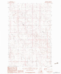
1983 Map of Sims Spring
USGS Topo · Published 1983About this map
Sims Spring marks a vital water source in this corner of Roosevelt County, Montana, where the arid landscape is defined by the drainage patterns of Boxelder Creek and Chelsea Creek. This 1983 provisional survey highlights the functional infrastructure of the high plains, illustrating how ranching and agricultural operations utilized the terrain. The presence of specific agricultural markers like Grain Bins and a remote Landing Strip suggests a period of industrialized farming where large-scale storage and aerial access were essential to local commerce. The map provides a detailed look at the section lines and topographic contours that guided land use during the early 1980s, offering a clear record of the rural Montana interior before modern digital mapping.
Find a feature on this map
5 named features on this map. Tap any name to fly to it.
Don’t see what you’re looking for? This feature index may not catch every label — zoom into the map to look around manually.
Map Details
Editions of this 1983 Sims Spring Map
This is the sole edition of this map. No revisions or reprints were ever made.
Other maps of this area

1910 · Cuskers
USGS Topo · 1:62,500

1912 · Chelsea
USGS Topo · 1:62,500

1915 · Tule Valley
USGS Topo · 1:62,500

1915 · Cuskers
USGS Topo · 1:62,500

1916 · Wolf Point
USGS Topo · 1:62,500

1954 · Wolf Point
USGS Topo · 1:250,000

1958 · Wolf Point
USGS Topo · 1:250,000

1972 · Chelsea
USGS Topo · 1:24,000

1972 · Chelsea NW
USGS Topo · 1:24,000
1972 · Wolf Point NE
USGS Topo · 1:24,000