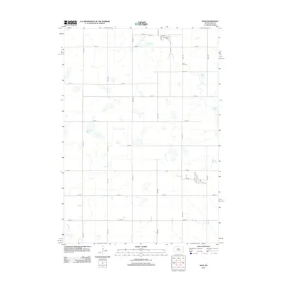
2012 Map of Sinai
USGS Topo · Published 2012About this map
Sinai Cem and East Sinai Cem overlook a landscape dominated by the distinctive prairie potholes of eastern South Dakota. This 2012 survey by the U.S. Geological Survey captures a region of intensive section-line farming interspersed with numerous named wetlands, including Bolstad Slough and Nelson Slough. The rural grid is anchored by the small village of Sinai, where Main Ave and Park Ave define the local center. To the west, East Lake Badus and Thompson Slough suggest the persistent hydrology of the terrain, while Battle Cr drains the southwestern corner. The map provides a detailed view of the rural infrastructure at the start of the decade, showing the precise alignment of numbered township roads like 217th St and 455th Ave that facilitate the agricultural economy of the Brookings County area.
Find a feature on this map
31 named features on this map. Tap any name to fly to it.
Don’t see what you’re looking for? This feature index may not catch every label — zoom into the map to look around manually.
Map Details
Editions of this 2012 Sinai Map
This is the sole edition of this map. No revisions or reprints were ever made.
Other maps of this area

1953 · Watertown
USGS Topo · 1:250,000

1958 · Watertown
USGS Topo · 1:250,000

1968 · Lake Sinai
USGS Topo · 1:24,000

1968 · Arlington
USGS Topo · 1:24,000

1968 · Volga
USGS Topo · 1:24,000

1968 · Ramona
USGS Topo · 1:24,000

1968 · Madison
USGS Topo · 1:24,000

1968 · Sinai
USGS Topo · 1:24,000
1968 · Madison NW
USGS Topo · 1:24,000
1968 · Rutland
USGS Topo · 1:24,000