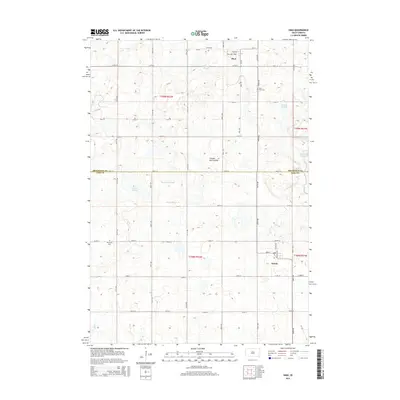
2015 Map of Sinai
USGS Topo · Published 2015About this map
The settlement of Sinai sits at the northern edge of this agricultural landscape in eastern South Dakota, positioned at the intersection of Main Ave and Park Ave. The terrain, identified as part of the Coteau des Prairies, is defined by a dense network of wetlands and shallow water bodies. These features, including Bolstad Slough, Nelson Slough, and Quam Slough, are scattered across the section lines, highlighting the post-glacial topography of the region. To the south, the village of Nunda marks the lower corner of the quadrangle near the boundary between Brookings and Lake counties.
Find a feature on this map
33 named features on this map. Tap any name to fly to it.
Don’t see what you’re looking for? This feature index may not catch every label — zoom into the map to look around manually.
Map Details
Editions of this 2015 Sinai Map
This is the sole edition of this map. No revisions or reprints were ever made.
Other maps of this area

1953 · Watertown
USGS Topo · 1:250,000

1958 · Watertown
USGS Topo · 1:250,000

1968 · Lake Sinai
USGS Topo · 1:24,000

1968 · Arlington
USGS Topo · 1:24,000

1968 · Volga
USGS Topo · 1:24,000

1968 · Ramona
USGS Topo · 1:24,000

1968 · Madison
USGS Topo · 1:24,000

1968 · Sinai
USGS Topo · 1:24,000
1968 · Madison NW
USGS Topo · 1:24,000
1968 · Rutland
USGS Topo · 1:24,000