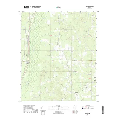
2018 Map of Singleton
USGS Topo · Published 2018About this map
Dossville and the community of Singleton anchor this landscape along the border of Attala Co and Leake Co. The topography is defined by the wetlands and tributaries of the Yockanookany River, including Conehoma Cr, Bokshenya Cr, and Socki Cr. The map reveals a high density of rural burial sites, such as Fletcher Cem in the north and Big Spring Cem in the south, which serve as critical markers for genealogists and local historians. The Natchez Trace Parkway cuts through the western edge of the quadrangle, paralleling the older corridor of Natchez St near McVille. This network of county roads and family-named landmarks like Turnage Cem reflects the enduring agricultural and residential patterns of this central Mississippi region.
Find a feature on this map
94 named features on this map. Tap any name to fly to it.
Don’t see what you’re looking for? This feature index may not catch every label — zoom into the map to look around manually.
Map Details
Editions of this 2018 Singleton Map
This is the sole edition of this map. No revisions or reprints were ever made.
Other maps of this area

1953 · Meridian
USGS Topo · 1:250,000

1953 · West Point
USGS Topo · 1:250,000

1957 · Meridian
USGS Topo · 1:250,000

1958 · West Point
USGS Topo · 1:250,000

1962 · Edinburg
USGS Topo · 1:62,500

1962 · Thomastown
USGS Topo · 1:62,500

1963 · West Point
USGS Topo · 1:250,000

1964 · Kosciusko
USGS Topo · 1:24,000
1964 · McAdams
USGS Topo · 1:24,000

1965 · Meridian
USGS Topo · 1:250,000