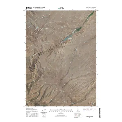
2017 Map of Sinker Canyon
USGS Topo · Published 2017About this map
Sinker Canyon serves as a central geological feature in this high-desert portion of Owyhee County, where deep drainages and intermittent creeks define the landscape. The infrastructure of the area revolves around water management and transit, anchored by the Hulet-Sinker Cr Reservoir and the Murphy Mutual Canal, which suggest a history of ranching and irrigation in this arid environment. Significant land routes such as Silver City Rd and Ridge Rd traverse the difficult terrain, connecting remote basins like Diamond Basin and Striker Basin Gulch. Local water sources like Diamond Creek Spring and Spring Ranch Spring provide critical points of interest for researchers tracing historical ranching boundaries or early wilderness travel through the Bates Cr and Fossil Cr drainages.
Find a feature on this map
28 named features on this map. Tap any name to fly to it.
Don’t see what you’re looking for? This feature index may not catch every label — zoom into the map to look around manually.
Map Details
Editions of this 2017 Sinker Canyon Map
This is the sole edition of this map. No revisions or reprints were ever made.
Other maps of this area

1892 · Bisuka
USGS Topo · 1:125,000

1892 · Silver City
USGS Topo · 1:125,000

1894 · Bisuka
USGS Topo · 1:125,000

1894 · Silver City
USGS Topo · 1:125,000

1898 · Silver City
USGS Topo · 1:125,000

1948 · Sinker Butte
USGS Topo · 1:24,000

1949 · Sinker Butte
USGS Topo · 1:24,000

1949 · Oreana
USGS Topo · 1:62,500
1949 · Oreana
USGS Topo · 1:24,000
1950 · Oreana
USGS Topo · 1:24,000