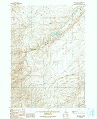
1990 Map of Sinker Canyon
USGS Topo · Published 1991About this map
Sinker Canyon and its complex network of seasonal drainages define this section of the Owyhee landscape during the early 1990s. The geography is characterized by deep ravines and high ridges, including Striker Ridge and Diamond Basin, which dictate the paths of early travel routes like Silver City Road. Human presence is marked by remnants of resource extraction and ranching, such as the Gilmore Ranch (Site), an Open Pit Mine, and various prospects scattered across the uplands. Water management is critical in this arid environment, evidenced by the Hulet-Sinker Creek Reservoir and numerous ditches and canals that divert flow from Sinker Creek. The northeastern corner of the sheet transitions toward the Snake River, falling within the protected Snake River Birds of Prey Area.
Find a feature on this map
31 named features on this map. Tap any name to fly to it.
Don’t see what you’re looking for? This feature index may not catch every label — zoom into the map to look around manually.
Map Details
Editions of this 1990 Sinker Canyon Map
This is the sole edition of this map. No revisions or reprints were ever made.
Other maps of this area

1892 · Bisuka
USGS Topo · 1:125,000

1892 · Silver City
USGS Topo · 1:125,000

1894 · Bisuka
USGS Topo · 1:125,000

1894 · Silver City
USGS Topo · 1:125,000

1898 · Silver City
USGS Topo · 1:125,000

1948 · Sinker Butte
USGS Topo · 1:24,000

1949 · Sinker Butte
USGS Topo · 1:24,000

1949 · Oreana
USGS Topo · 1:62,500
1949 · Oreana
USGS Topo · 1:24,000
1950 · Oreana
USGS Topo · 1:24,000