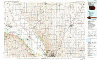
1986 Map of Sioux City North
USGS Topo · Published 1992About this map
The Missouri River and Big Sioux River define the tri-state convergence where Iowa, Nebraska, and South Dakota meet during the late twentieth century. This region is anchored by Le Mars and the academic campuses of Briar Cliff College and the University of South Dakota. The landscape transitions from the river bottomlands, featuring Mc Cook Lake and Burbank Lake, to the upland prairies marked by topographic landmarks like Spirit Mound and Volcano Hill.
Find a feature on this map
103 named features on this map. Tap any name to fly to it.
Don’t see what you’re looking for? This feature index may not catch every label — zoom into the map to look around manually.
Map Details
Editions of this 1986 Sioux City North Map
2 editions found
Other maps of this area

1897 · Canton
USGS Topo · 1:125,000

1898 · Parker
USGS Topo · 1:125,000

1898 · Elk Point
USGS Topo · 1:125,000

1900 · Canton
USGS Topo · 1:125,000

1901 · Elk Point
USGS Topo · 1:125,000

1907 · Elk Point
USGS Topo · 1:125,000

1954 · Fairmont
USGS Topo · 1:250,000

1954 · Fort Dodge
USGS Topo · 1:250,000

1955 · Sioux City
USGS Topo · 1:250,000

1955 · Sioux Falls
USGS Topo · 1:250,000