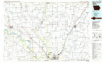
1986 Map of Sioux City North
USGS Topo · Published 1986About this map
The Missouri River and Big Sioux River define the tri-state geography of this mid-1980s landscape, where the borders of Iowa, South Dakota, and Nebraska converge. Centered on the fertile plains north of Sioux City, the map reveals a dense network of farming townships like Pleasant Valley and Elkhorn connected by the rails of the Burlington Northern and Chicago and North Western. Key regional hubs such as Le Mars, Hawarden, and Vermillion—home to the University of South Dakota—stand out against the gridded rural sections. Notable topographic and recreational landmarks including Spirit Mound, Stone State Park, and Ponca State Park provide contrast to the industrial presence of numerous Gravel Pits and quarries scattered throughout the valley, reflecting the local geology and extraction economy of the period.
Find a feature on this map
151 named features on this map. Tap any name to fly to it.
Don’t see what you’re looking for? This feature index may not catch every label — zoom into the map to look around manually.
Map Details
Editions of this 1986 Sioux City North Map
2 editions found
Other maps of this area

1897 · Canton
USGS Topo · 1:125,000

1898 · Parker
USGS Topo · 1:125,000

1898 · Elk Point
USGS Topo · 1:125,000

1900 · Canton
USGS Topo · 1:125,000

1901 · Elk Point
USGS Topo · 1:125,000

1907 · Elk Point
USGS Topo · 1:125,000

1954 · Fairmont
USGS Topo · 1:250,000

1954 · Fort Dodge
USGS Topo · 1:250,000

1955 · Sioux City
USGS Topo · 1:250,000

1955 · Sioux Falls
USGS Topo · 1:250,000