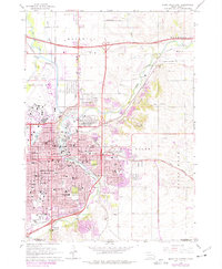
1962 Map of Sioux Falls East
USGS Topo · Published 1977About this map
Sioux Falls serves as the focal point of this mid-century survey, revealing a landscape defined by the winding course of the Big Sioux River and a dense network of early transportation routes. The city's institutional history is prominent, featuring Augustana College, Sioux Falls College, and the State Prison complex north of the downtown core. The geography of the era is marked by significant industrial and transportation infrastructure, including the convergence of the Burlington Northern, Chicago and North Western, and Chicago Milwaukee St Paul and Pacific railroads. Outside the urban center, the map captures the transition to rural areas like Mapleton and Brandon, while documenting numerous local landmarks such as Woodlawn Cemetery, the School for the Deaf, and the Cactus Hills region east of the river.
Find a feature on this map
79 named features on this map. Tap any name to fly to it.
Don’t see what you’re looking for? This feature index may not catch every label — zoom into the map to look around manually.
Map Details
Editions of this 1962 Sioux Falls East Map
3 editions found
Other maps of this area

1897 · Canton
USGS Topo · 1:125,000

1900 · Canton
USGS Topo · 1:125,000

1955 · Sioux Falls
USGS Topo · 1:250,000

1958 · Sioux Falls
USGS Topo · 1:250,000

1962 · Renner
USGS Topo · 1:24,000

1962 · Klondike
USGS Topo · 1:24,000

1962 · Harrisburg
USGS Topo · 1:24,000

1962 · Brandon
USGS Topo · 1:24,000

1962 · Sioux Falls East
USGS Topo · 1:24,000

1962 · Tea
USGS Topo · 1:24,000