
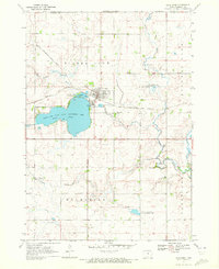
1960 Map of Sioux Valley
USGS Topo · Published 1962About this map
The Little Sioux River and its West Fork define this agricultural landscape along the Minnesota and Iowa border during the early 1960s. The area is characterized by a high concentration of water management features, including the prominent Judicial Ditch and County Ditch No 11, which drain the lowlands surrounding Skunk Lake and Rush Lake. These engineering works highlight the era's intensive efforts to reclaim and maintain productive prairie farmland.
Find a feature on this map
23 named features on this map. Tap any name to fly to it.
Don’t see what you’re looking for? This feature index may not catch every label — zoom into the map to look around manually.
Map Details
Editions of this 1960 Sioux Valley Map
This is the sole edition of this map. No revisions or reprints were ever made.
Other maps of this area

1954 · Fairmont
USGS Topo · 1:250,000

1958 · Fairmont
USGS Topo · 1:250,000

1960 · Brewster
USGS Topo · 1:24,000

1960 · Okabena
USGS Topo · 1:24,000

1960 · Round Lake
USGS Topo · 1:24,000

1970 · Lakefield SW
USGS Topo · 1:24,000

1970 · Okoboji
USGS Topo · 1:24,000

1970 · Lakefield
USGS Topo · 1:24,000

1970 · Harris
USGS Topo · 1:24,000
1970 · Lake Park
USGS Topo · 1:24,000