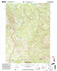
2001 Map of Siskiyou Pass
USGS Topo · Published 2004About this map
Siskiyou Pass and Siskiyou Summit define this high-elevation corridor along the Oregon California border at the turn of the 21st century. This survey documents a landscape focused on transportation and water management, where the Pacific Crest National Scenic Trail winds through the Siskiyou Mountains near the Green Springs Powerplant. Historically significant markers of earlier settlement and industry appear as the Dollarhide (Site), the railroad siding at Steinman, and a Mine Tunnel near Buck Rock. The intricate drainage patterns of Emigrant Creek and Ashland Creek are visible as they descend from prominent peaks like Pilot Rock and Little Pilot Rock. Significant portions of the southern terrain are protected within the Klamath National Forest, showing the intersection of public lands and the rugged divide between Jackson and Siskiyou counties.
Find a feature on this map
35 named features on this map. Tap any name to fly to it.
Don’t see what you’re looking for? This feature index may not catch every label — zoom into the map to look around manually.
Map Details
Editions of this 2001 Siskiyou Pass Map
This is the sole edition of this map. No revisions or reprints were ever made.
Other maps of this area

1886 · Shasta
USGS Topo · 1:250,000

1891 · Ashland
USGS Topo · 1:250,000

1893 · Ashland
USGS Topo · 1:250,000

1894 · Shasta
USGS Topo · 1:250,000

1897 · Ashland
USGS Topo · 1:250,000

1922 · Shasta Valley Sheet No 15
USGS Topo · 1:24,000

1932 · Yreka
USGS Topo · 1:96,000

1934 · Macdoel
USGS Topo · 1:96,000

1938 · Medford
USGS Topo · 1:125,000

1939 · Yreka
USGS Topo · 1:125,000