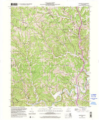
2000 Map of Sissonville
USGS Topo · Published 2001About this map
Sissonville sits at the confluence of the Pocatalico River and its various branches, serving as a focal point for this rural West Virginia landscape. The terrain is characterized by a dense network of ridges such as Allen Ridge and Hogpen Ridge, which dictated the location of early roads and small settlements like Goldtown and Liberty. This edition, while photoinspected at the turn of the millennium, preserves a settlement pattern defined by community institutions, including numerous country schools like Unexpected Sch and Sayre Sch. Religious life is deeply etched into the topography through landmarks like Bonham Chapel, White Chapel, and Allens Chapel. The introduction of I-77 represents a modern layer over the traditional valley-and-ridge lifestyle, yet the abundance of family-named cemeteries such as Smith Cem and Fisher Cem points to long-standing genealogical roots in the hollows and along the many forks of the Pocatalico.
Find a feature on this map
87 named features on this map. Tap any name to fly to it.
Don’t see what you’re looking for? This feature index may not catch every label — zoom into the map to look around manually.
Map Details
Editions of this 2000 Sissonville Map
This is the sole edition of this map. No revisions or reprints were ever made.
Other maps of this area

1899 · Charleston
USGS Topo · 1:125,000

1906 · Kenna
USGS Topo · 1:62,500

1906 · Winfield
USGS Topo · 1:62,500

1907 · Kenna
USGS Topo · 1:62,500

1908 · Winfield
USGS Topo · 1:62,500

1909 · Charleston
USGS Topo · 1:62,500

1909 · Saint Albans
USGS Topo · 1:62,500

1931 · Saint Albans
USGS Topo · 1:62,500

1931 · Charleston
USGS Topo · 1:62,500

1933 · Saint Albans
USGS Topo · 1:62,500