
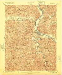
1909 Map of Saint Albans
USGS Topo · Published 1909About this map
Saint Albans serves as a vital river and rail hub in this early twentieth-century survey, positioned where the Coal River meets the Kanawha River. The landscape is defined by the heavy infrastructure of the Chesapeake and Ohio RR and the strategic Lock Seven, facilitating the movement of resources through the Teays Valley. Significant for genealogists, the map identifies numerous rural institutions including the Mt Vernon School, Harmony School, and a county Infirmary near Hurricane. Small riverside settlements like Black Betsey and Raymond dot the northern banks, while the interior is marked by long-standing post offices at Tornado PO Upper Falls and Alum Creek Rome PO. The network of tributary runs and branches, such as Little Scary Creek and Upton Creek, illustrates the intricate drainage patterns that dictated the placement of early homesteads and mountain roads.
Find a feature on this map
98 named features on this map. Tap any name to fly to it.
Don’t see what you’re looking for? This feature index may not catch every label — zoom into the map to look around manually.
Map Details
Editions of this 1909 Saint Albans Map
2 editions found
Other maps of this area

1892 · Huntington
USGS Topo · 1:125,000

1898 · Huntington
USGS Topo · 1:125,000

1899 · Charleston
USGS Topo · 1:125,000

1902 · Milton
USGS Topo · 1:62,500

1902 · Midkiff
USGS Topo · 1:62,500

1906 · Glenwood
USGS Topo · 1:62,500

1906 · Kenna
USGS Topo · 1:62,500

1906 · Winfield
USGS Topo · 1:62,500

1907 · Kenna
USGS Topo · 1:62,500

1907 · Midkiff
USGS Topo · 1:62,500