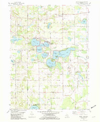
1981 Map of Sister Lakes
USGS Topo · Published 1982About this map
The glacial kettle lakes of Southwest Michigan define the landscape of this 1981 survey, where the resort community of Sister Lakes sits at the intersection of Van Buren and Cass counties. The area is characterized by a dense concentration of water bodies, including the large Magician Lake with its named landforms like Rattlesnake Island and Maple Island. Small clusters of development such as Woodland Beach and Sandy Beach line the shores, reflecting the mid-century growth of seasonal and permanent lakeside residences. Rural life away from the water is anchored by longstanding institutions like the Sacred Heart of Mary Ch and Silver Creek Ch, along with several family-associated burial grounds including Grabemeyer Cem and Cullinane Cem. To the north, the settlement of Keeler serves as a local hub along Territorial Road, while the southern reaches transition toward the Dowagiac River valley near Beechwood.
Find a feature on this map
66 named features on this map. Tap any name to fly to it.
Don’t see what you’re looking for? This feature index may not catch every label — zoom into the map to look around manually.
Map Details
Editions of this 1981 Sister Lakes Map
This is the sole edition of this map. No revisions or reprints were ever made.
Other maps of this area

1927 · Niles
USGS Topo · 1:62,500

1927 · Hartford
USGS Topo · 1:62,500

1927 · Benton Harbor
USGS Topo · 1:62,500

1930 · Benton Harbor
USGS Topo · 1:62,500

1930 · Niles
USGS Topo · 1:62,500

1931 · Hartford
USGS Topo · 1:62,500

1943 · Niles
USGS Topo · 1:62,500

1945 · Cassopolis
USGS Topo · 1:62,500

1947 · Cassopolis
USGS Topo · 1:62,500

1953 · Chicago
USGS Topo · 1:250,000