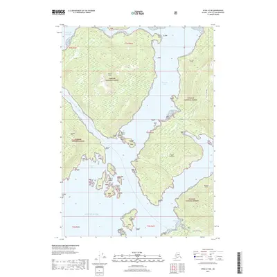
2017 Map of Sitka A-5 NE
USGS Topo · Published 2017About this map
The Lisianski Peninsula dominates this coastal landscape, separating the sheltered waters of Nakwasina Sound from the open expanse of the Gulf of Alaska. This 2017 study illustrates a complex archipelago within the Tongass National Forest, where the land is deeply indented by inlets like Cedar Cove and Katlian Bay. On Halleck Island and the neighboring Baranof Island, the topography rises sharply from the shoreline, with Krestof Mtn providing a significant vertical landmark on the western edge. Human activity is concentrated along the southern coast, where Halibut Point Road and the Nelson Logging Road provide access near Starrigavan Bay. The map reveals the intricate navigation required through the Nakwasina Passage and among the Siginaka Islands, documenting the modern infrastructure and natural boundaries of this maritime environment.
Find a feature on this map
36 named features on this map. Tap any name to fly to it.
Don’t see what you’re looking for? This feature index may not catch every label — zoom into the map to look around manually.
Map Details
Editions of this 2017 Sitka A-5 NE Map
This is the sole edition of this map. No revisions or reprints were ever made.
Other maps of this area

1948 · Sitka A-5
USGS Topo · 1:63,360

1948 · Sitka B-5
USGS Topo · 1:63,360

1951 · Sitka B-4
USGS Topo · 1:63,360

1951 · Sitka B-5
USGS Topo · 1:63,360

1951 · Sitka
USGS Topo · 1:250,000

1951 · Sitka A-4
USGS Topo · 1:63,360

1951 · Sitka A-5
USGS Topo · 1:63,360

1952 · Sitka
USGS Topo · 1:250,000

1954 · Sitka A-4
USGS Topo · 1:63,360

1964 · Sitka
USGS Topo · 1:250,000