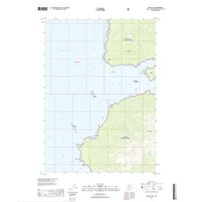
2017 Map of Sitka B-2 SW
USGS Topo · Published 2017About this map
Tongass National Forest dominates the coastal landscape of this quadrangle, where the steep topography of Admiralty Island meets the cold waters of the Gulf of Alaska. The shoreline is a jagged succession of landmarks, from the northern prominence of Village Point down to the southern reaches of Woody Point. Maritime navigation is the primary focus of the coastal markings, noting hazards like the offshore Russian Reef situated between the wide openings of Chaik Bay and Whitewater Bay. The interior is largely defined by the dense forest and high-elevation contours typical of Southeast Alaska's wilderness, showing a land untouched by road infrastructure. This 2017 survey captures the timeless character of the island’s western edge, where the vast Pacific Ocean begins its reach toward the coast, shaped by the Tongass National Forest management boundaries.
Find a feature on this map
14 named features on this map. Tap any name to fly to it.
Don’t see what you’re looking for? This feature index may not catch every label — zoom into the map to look around manually.
Map Details
Editions of this 2017 Sitka B-2 SW Map
This is the sole edition of this map. No revisions or reprints were ever made.
Other maps of this area

1948 · Sitka B-3
USGS Topo · 1:63,360

1948 · Sitka A-3
USGS Topo · 1:63,360

1948 · Sitka A-2
USGS Topo · 1:63,360

1948 · Sitka B-2
USGS Topo · 1:63,360

1951 · Sitka
USGS Topo · 1:250,000

1951 · Sitka B-3
USGS Topo · 1:63,360

1951 · Sitka A-2
USGS Topo · 1:63,360
1951 · Sitka A-3
USGS Topo · 1:63,360

1951 · Sitka B-2
USGS Topo · 1:63,360

1952 · Sitka
USGS Topo · 1:250,000