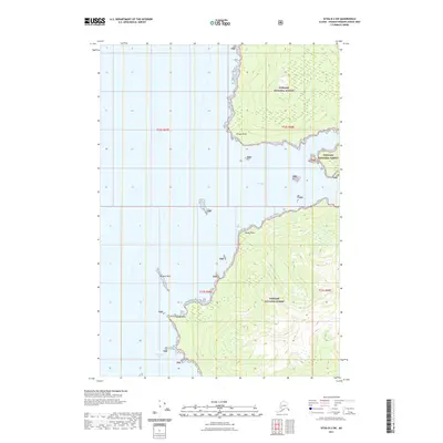
2021 Map of Sitka B-2 SW
USGS Topo · Published 2021About this map
Chaik Bay and Whitewater Bay dominate this coastal survey, where the saltwater inlets of Admiralty Island meet the dense maritime woods of the Tongass National Forest. The map illustrates a complex shoreline defined by prominent landmarks such as Village Point to the north and the jagged reach of Russian Reef further south. Between these features, the land rises sharply from the tide line toward inland peaks, with Rocky Point and Woody Point serving as key navigation markers for those traversing these Southeast Alaska waters. This 2021 edition provides a clear view of the wilderness character of the region, emphasizing the interplay between the deep-water bays and the protected forest lands that have long supported the local fishing and timber economies.
Find a feature on this map
12 named features on this map. Tap any name to fly to it.
Don’t see what you’re looking for? This feature index may not catch every label — zoom into the map to look around manually.
Map Details
Editions of this 2021 Sitka B-2 SW Map
This is the sole edition of this map. No revisions or reprints were ever made.
Other maps of this area

1948 · Sitka B-3
USGS Topo · 1:63,360

1948 · Sitka A-3
USGS Topo · 1:63,360

1948 · Sitka A-2
USGS Topo · 1:63,360

1948 · Sitka B-2
USGS Topo · 1:63,360

1951 · Sitka
USGS Topo · 1:250,000

1951 · Sitka B-3
USGS Topo · 1:63,360

1951 · Sitka A-2
USGS Topo · 1:63,360
1951 · Sitka A-3
USGS Topo · 1:63,360

1951 · Sitka B-2
USGS Topo · 1:63,360

1952 · Sitka
USGS Topo · 1:250,000