
1951 Map of Sitka C-1
USGS Topo · Published 1968About this map
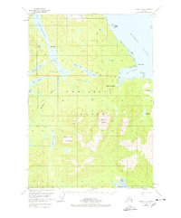
Hasselborg Lake and the interior waterways of Admiralty Island dominate this mid-century survey, revealing a landscape defined by its interconnected lakes and coastal inlets. The map documents sparse human footprints in the Tongass National Forest, most notably the Hasselborg Homestead and Camp Shaheen, providing a rare record of early inland habitation. The terrain is structured by high peaks like Botany Peak and the Yellow Bear Mountains, with the extensive drainages of Hasselborg Creek and Jims Creek carving paths through the dense forest. Along the eastern shoreline, Mole Harbor and Seymour Canal appear as they did before modern maritime shifts, featuring landmarks like Rasp Ledge and Beacon Rk that served as vital navigational points for those traversing the Alaskan panhandle by water.
Find a feature on this map
32 named features on this map. Tap any name to fly to it.
Don’t see what you’re looking for? This feature index may not catch every label — zoom into the map to look around manually.
Map Details
Editions of this 1951 Sitka C-1 Map
3 editions found
Historical Maps of Unorganized Borough Through Time
525 maps found

1943 Sumdum B-4
Hoonah-Angoon Borough, AK

1948 Juneau A-3
Hoonah-Angoon Borough, AK

1948 Juneau A-4
Hoonah-Angoon Borough, AK

1948 Juneau B-5
Hoonah-Angoon Borough, AK

1948 Juneau B-6
Hoonah-Angoon Borough, AK

1948 Juneau C-5
Hoonah-Angoon Borough, AK

1948 Juneau C-6
Hoonah-Angoon Borough, AK

1948 Mount Fairweather A-1
Hoonah-Angoon Borough, AK

1948 Mount Fairweather A-2
Hoonah-Angoon Borough, AK

1948 Mount Fairweather B-1
Hoonah-Angoon Borough, AK

1948 Mount Fairweather B-2
Hoonah-Angoon Borough, AK

1948 Mount Fairweather C-1
Hoonah-Angoon Borough, AK

1948 Mount Fairweather C-2
Hoonah-Angoon Borough, AK

1948 Mt. Fairweather D-1
Hoonah-Angoon Borough, AK

1948 Mt. Fairweather D-2
Hoonah-Angoon Borough, AK

1948 Port Alexander D-1
Hoonah-Angoon Borough, AK

1948 Sitka A-1
Hoonah-Angoon Borough, AK

1948 Sitka A-2
Hoonah-Angoon Borough, AK

1948 Sitka B-1
Hoonah-Angoon Borough, AK

1948 Sitka B-2
Hoonah-Angoon Borough, AK

1948 Sitka C-1
Hoonah-Angoon Borough, AK

1948 Sitka C-2
Hoonah-Angoon Borough, AK

1948 Sitka D-1
Hoonah-Angoon Borough, AK

1948 Sitka D-2
Hoonah-Angoon Borough, AK

1948 Sitka D-3
Hoonah-Angoon Borough, AK

1948 Sitka D-4
Hoonah-Angoon Borough, AK

1948 Sitka D-5
Hoonah-Angoon Borough, AK

1948 Sitka D-8
Hoonah-Angoon Borough, AK

1948 Sumdum A-4
Hoonah-Angoon Borough, AK

1948 Sumdum A-5
Hoonah-Angoon Borough, AK

1948 Sumdum A-6
Hoonah-Angoon Borough, AK

1948 Sumdum B-4
Hoonah-Angoon Borough, AK

1948 Sumdum B-5
Hoonah-Angoon Borough, AK

1948 Sumdum B-6
Hoonah-Angoon Borough, AK

1948 Sumdum C-5
Hoonah-Angoon Borough, AK

1948 Sumdum C-6
Hoonah-Angoon Borough, AK

1948 Sumdum D-5
Hoonah-Angoon Borough, AK

1949 Juneau D-6
Hoonah-Angoon Borough, AK

1949 Mount Fairweather C-1
Hoonah-Angoon Borough, AK

1950 Juneau A-3
Hoonah-Angoon Borough, AK

1950 Juneau B-5
Hoonah-Angoon Borough, AK

1950 Juneau C-6
Hoonah-Angoon Borough, AK

1950 Mount Fairweather C-2
Hoonah-Angoon Borough, AK

1950 Mount Fairweather D-2
Hoonah-Angoon Borough, AK

1950 Sitka D-8
Hoonah-Angoon Borough, AK

1951 Juneau A-5
Hoonah-Angoon Borough, AK

1951 Juneau A-6
Hoonah-Angoon Borough, AK

1951 Mt Fairweather
Hoonah-Angoon Borough, AK

1951 Port Alexander D-2
Hoonah-Angoon Borough, AK

1951 Sitka A-2
Hoonah-Angoon Borough, AK

1951 Sitka B-1
Hoonah-Angoon Borough, AK

1951 Sitka B-2
Hoonah-Angoon Borough, AK

1951 Sitka C-1
Hoonah-Angoon Borough, AK

1951 Sitka C-2
Hoonah-Angoon Borough, AK

1951 Sitka D-1
Hoonah-Angoon Borough, AK

1951 Sitka D-2
Hoonah-Angoon Borough, AK

1951 Sitka D-3
Hoonah-Angoon Borough, AK

1951 Sitka D-5
Hoonah-Angoon Borough, AK

1951 Sitka D-7
Hoonah-Angoon Borough, AK

1951 Sumdum A-4
Hoonah-Angoon Borough, AK

1951 Sumdum B-5
Hoonah-Angoon Borough, AK

1951 Sumdum C-5
Hoonah-Angoon Borough, AK

1951 Sumdum C-6
Hoonah-Angoon Borough, AK

1951 Taku River A-4
Hoonah-Angoon Borough, AK

1952 Sumdum
Hoonah-Angoon Borough, AK

1954 Mount Fairweather A-1
Hoonah-Angoon Borough, AK

1954 Mount Fairweather D-1
Hoonah-Angoon Borough, AK

1954 Skagway A-3
Hoonah-Angoon Borough, AK

1955 Sitka D-4
Hoonah-Angoon Borough, AK

1955 Sumdum D-5
Hoonah-Angoon Borough, AK

1960 Sumdum D-4
Hoonah-Angoon Borough, AK

1961 Mount Fairweather A-3
Hoonah-Angoon Borough, AK

1961 Mount Fairweather B-3
Hoonah-Angoon Borough, AK

1961 Mount Fairweather C-3
Hoonah-Angoon Borough, AK

1961 Mount Fairweather C-4
Hoonah-Angoon Borough, AK

1961 Mount Fairweather C-5
Hoonah-Angoon Borough, AK

1961 Mount Fairweather C-6
Hoonah-Angoon Borough, AK

1961 Mount Fairweather D-3
Hoonah-Angoon Borough, AK

1961 Mount Fairweather D-4
Hoonah-Angoon Borough, AK

1961 Mount Fairweather D-5
Hoonah-Angoon Borough, AK

1961 Mt Fairweather B-4
Hoonah-Angoon Borough, AK

1961 Mt Fairweather
Hoonah-Angoon Borough, AK

1961 Skagway A-4
Hoonah-Angoon Borough, AK

1961 Skagway A-5
Hoonah-Angoon Borough, AK

1961 Skagway A-6
Hoonah-Angoon Borough, AK

1961 Sumdum B-2
Hoonah-Angoon Borough, AK

1961 Sumdum B-3
Hoonah-Angoon Borough, AK

1961 Sumdum C-2
Hoonah-Angoon Borough, AK

1961 Sumdum C-3
Hoonah-Angoon Borough, AK

1961 Sumdum C-4
Hoonah-Angoon Borough, AK

1961 Sumdum D-3
Hoonah-Angoon Borough, AK

1961 Sumdum
Hoonah-Angoon Borough, AK

1986 Juneau B-3 SW
Hoonah-Angoon Borough, AK

1994 Juneau A-5
Hoonah-Angoon Borough, AK

1994 Sumdum A-6
Hoonah-Angoon Borough, AK

1994 Sumdum D-4
Hoonah-Angoon Borough, AK

1994 Sumdum D-5
Hoonah-Angoon Borough, AK

1995 Juneau A-4
Hoonah-Angoon Borough, AK

1995 Port Alexander D-2
Hoonah-Angoon Borough, AK

1995 Sitka D-8
Hoonah-Angoon Borough, AK

1996 Sumdum B-3
Hoonah-Angoon Borough, AK

1996 Sumdum B-4
Hoonah-Angoon Borough, AK

1996 Sumdum B-5
Hoonah-Angoon Borough, AK

1997 Juneau A-3
Hoonah-Angoon Borough, AK

1997 Port Alexander D-1
Hoonah-Angoon Borough, AK

1997 Sitka D-2
Hoonah-Angoon Borough, AK

1997 Sitka D-3
Hoonah-Angoon Borough, AK

1997 Sitka D-4
Hoonah-Angoon Borough, AK

1997 Sitka D-5
Hoonah-Angoon Borough, AK

1997 Sitka D-7
Hoonah-Angoon Borough, AK

2000 Juneau A-6
Hoonah-Angoon Borough, AK

2000 Sitka B-2
Hoonah-Angoon Borough, AK

2000 Sumdum B-2
Hoonah-Angoon Borough, AK

2000 Sumdum C-3
Hoonah-Angoon Borough, AK

2015 Juneau A-5 NE
Hoonah-Angoon Borough, AK

2015 Juneau A-5 NW
Hoonah-Angoon Borough, AK

2015 Juneau A-6 NE
Hoonah-Angoon Borough, AK

2015 Juneau A-6 NW
Hoonah-Angoon Borough, AK

2015 Juneau B-5 NW
Hoonah-Angoon Borough, AK

2015 Juneau B-5 SW
Hoonah-Angoon Borough, AK

2015 Juneau B-6 NE
Hoonah-Angoon Borough, AK

2015 Juneau B-6 SE
Hoonah-Angoon Borough, AK

2017 Juneau A-1 SE
Hoonah-Angoon Borough, AK

2017 Juneau A-1 SW
Hoonah-Angoon Borough, AK

2017 Juneau A-2 SE
Hoonah-Angoon Borough, AK

2017 Juneau A-2 SW
Hoonah-Angoon Borough, AK

2017 Juneau A-3 NE
Hoonah-Angoon Borough, AK

2017 Juneau A-3 NW
Hoonah-Angoon Borough, AK

2017 Juneau A-3 SE
Hoonah-Angoon Borough, AK

2017 Juneau A-3 SW
Hoonah-Angoon Borough, AK

2017 Juneau A-4 SE
Hoonah-Angoon Borough, AK

2017 Juneau A-4 SW
Hoonah-Angoon Borough, AK

2017 Juneau A-5 SE
Hoonah-Angoon Borough, AK

2017 Juneau A-5 SW
Hoonah-Angoon Borough, AK

2017 Juneau A-6 SE
Hoonah-Angoon Borough, AK

2017 Juneau A-6 SW
Hoonah-Angoon Borough, AK

2017 Juneau B-3 SW
Hoonah-Angoon Borough, AK

2017 Juneau B-6 NW
Hoonah-Angoon Borough, AK

2017 Juneau B-6 SW
Hoonah-Angoon Borough, AK

2017 Juneau C-5 NW
Hoonah-Angoon Borough, AK

2017 Juneau C-5 SE
Hoonah-Angoon Borough, AK

2017 Juneau C-5 SW
Hoonah-Angoon Borough, AK

2017 Juneau C-6 NE
Hoonah-Angoon Borough, AK

2017 Juneau C-6 NW
Hoonah-Angoon Borough, AK

2017 Juneau C-6 SE
Hoonah-Angoon Borough, AK

2017 Juneau C-6 SW
Hoonah-Angoon Borough, AK

2017 Juneau D-5 NW
Hoonah-Angoon Borough, AK

2017 Juneau D-6 NE
Hoonah-Angoon Borough, AK

2017 Juneau D-6 NW
Hoonah-Angoon Borough, AK

2017 Juneau D-6 SE
Hoonah-Angoon Borough, AK

2017 Juneau D-6 SW
Hoonah-Angoon Borough, AK

2017 Mount Fairweather A-1 NE
Hoonah-Angoon Borough, AK

2017 Mount Fairweather A-1 NW
Hoonah-Angoon Borough, AK

2017 Mount Fairweather A-1 SE
Hoonah-Angoon Borough, AK

2017 Mount Fairweather A-1 SW
Hoonah-Angoon Borough, AK

2017 Mount Fairweather A-2 NE
Hoonah-Angoon Borough, AK

2017 Mount Fairweather A-2 NW
Hoonah-Angoon Borough, AK

2017 Mount Fairweather A-2 SE
Hoonah-Angoon Borough, AK

2017 Mount Fairweather A-2 SW
Hoonah-Angoon Borough, AK

2017 Mount Fairweather A-3 NE
Hoonah-Angoon Borough, AK

2017 Mount Fairweather B-1 NE
Hoonah-Angoon Borough, AK

2017 Mount Fairweather B-1 NW
Hoonah-Angoon Borough, AK

2017 Mount Fairweather B-1 SE
Hoonah-Angoon Borough, AK

2017 Mount Fairweather B-1 SW
Hoonah-Angoon Borough, AK

2017 Mount Fairweather B-2 NE
Hoonah-Angoon Borough, AK

2017 Mount Fairweather B-2 NW
Hoonah-Angoon Borough, AK

2017 Mount Fairweather B-2 SE
Hoonah-Angoon Borough, AK

2017 Mount Fairweather B-2 SW
Hoonah-Angoon Borough, AK

2017 Mount Fairweather B-3 NE
Hoonah-Angoon Borough, AK

2017 Mount Fairweather B-3 NW
Hoonah-Angoon Borough, AK

2017 Mount Fairweather B-3 SE
Hoonah-Angoon Borough, AK

2017 Mount Fairweather B-3 SW
Hoonah-Angoon Borough, AK

2017 Mount Fairweather B-4 NE
Hoonah-Angoon Borough, AK

2017 Mount Fairweather B-4 NW
Hoonah-Angoon Borough, AK

2017 Mount Fairweather B-4 OE W NE
Hoonah-Angoon Borough, AK

2017 Mount Fairweather C-1 NE
Hoonah-Angoon Borough, AK

2017 Mount Fairweather C-1 NW
Hoonah-Angoon Borough, AK

2017 Mount Fairweather C-1 SE
Hoonah-Angoon Borough, AK

2017 Mount Fairweather C-1 SW
Hoonah-Angoon Borough, AK

2017 Mount Fairweather C-2 NE
Hoonah-Angoon Borough, AK

2017 Mount Fairweather C-2 NW
Hoonah-Angoon Borough, AK

2017 Mount Fairweather C-2 SE
Hoonah-Angoon Borough, AK

2017 Mount Fairweather C-2 SW
Hoonah-Angoon Borough, AK

2017 Mount Fairweather C-3 NE
Hoonah-Angoon Borough, AK

2017 Mount Fairweather C-3 NW
Hoonah-Angoon Borough, AK

2017 Mount Fairweather C-3 SE
Hoonah-Angoon Borough, AK

2017 Mount Fairweather C-3 SW
Hoonah-Angoon Borough, AK

2017 Mount Fairweather C-4 NE
Hoonah-Angoon Borough, AK

2017 Mount Fairweather C-4 NW
Hoonah-Angoon Borough, AK

2017 Mount Fairweather C-4 SE
Hoonah-Angoon Borough, AK

2017 Mount Fairweather C-4 SW
Hoonah-Angoon Borough, AK

2017 Mount Fairweather C-5 NE
Hoonah-Angoon Borough, AK

2017 Mount Fairweather C-5 NW
Hoonah-Angoon Borough, AK

2017 Mount Fairweather C-5 SE
Hoonah-Angoon Borough, AK

2017 Mount Fairweather C-5 SW
Hoonah-Angoon Borough, AK

2017 Mount Fairweather C-6 NE
Hoonah-Angoon Borough, AK

2017 Mount Fairweather C-6 NW
Hoonah-Angoon Borough, AK

2017 Mount Fairweather C-6 SE
Hoonah-Angoon Borough, AK

2017 Mount Fairweather D-1 NE
Hoonah-Angoon Borough, AK

2017 Mount Fairweather D-1 NW
Hoonah-Angoon Borough, AK

2017 Mount Fairweather D-1 SE
Hoonah-Angoon Borough, AK

2017 Mount Fairweather D-1 SW
Hoonah-Angoon Borough, AK

2017 Mount Fairweather D-2 NE
Hoonah-Angoon Borough, AK

2017 Mount Fairweather D-2 NW
Hoonah-Angoon Borough, AK

2017 Mount Fairweather D-2 SE
Hoonah-Angoon Borough, AK

2017 Mount Fairweather D-2 SW
Hoonah-Angoon Borough, AK

2017 Mount Fairweather D-3 NE
Hoonah-Angoon Borough, AK

2017 Mount Fairweather D-3 NW
Hoonah-Angoon Borough, AK

2017 Mount Fairweather D-3 SE
Hoonah-Angoon Borough, AK

2017 Mount Fairweather D-3 SW
Hoonah-Angoon Borough, AK

2017 Mount Fairweather D-4 NE
Hoonah-Angoon Borough, AK

2017 Mount Fairweather D-4 NW
Hoonah-Angoon Borough, AK

2017 Mount Fairweather D-4 SE
Hoonah-Angoon Borough, AK

2017 Mount Fairweather D-4 SW
Hoonah-Angoon Borough, AK

2017 Mount Fairweather D-5 NE
Hoonah-Angoon Borough, AK

2017 Mount Fairweather D-5 SE
Hoonah-Angoon Borough, AK

2017 Mount Fairweather D-5 SW
Hoonah-Angoon Borough, AK

2017 Mount Fairweather D-6 SE
Hoonah-Angoon Borough, AK

2017 Port Alexander D-1 NW
Hoonah-Angoon Borough, AK

2017 Port Alexander D-2 NE
Hoonah-Angoon Borough, AK

2017 Sitka A-1 NE
Hoonah-Angoon Borough, AK

2017 Sitka A-1 SE
Hoonah-Angoon Borough, AK

2017 Sitka A-1 SW
Hoonah-Angoon Borough, AK

2017 Sitka A-2 NE
Hoonah-Angoon Borough, AK

2017 Sitka A-2 NW
Hoonah-Angoon Borough, AK

2017 Sitka A-2 SE
Hoonah-Angoon Borough, AK

2017 Sitka A-2 SW
Hoonah-Angoon Borough, AK

2017 Sitka B-1 NE
Hoonah-Angoon Borough, AK

2017 Sitka B-1 NW
Hoonah-Angoon Borough, AK

2017 Sitka B-1 SE
Hoonah-Angoon Borough, AK

2017 Sitka B-1 SW
Hoonah-Angoon Borough, AK

2017 Sitka B-2 NE
Hoonah-Angoon Borough, AK

2017 Sitka B-2 NW
Hoonah-Angoon Borough, AK

2017 Sitka B-2 SE
Hoonah-Angoon Borough, AK

2017 Sitka B-2 SW
Hoonah-Angoon Borough, AK

2017 Sitka C-1 NE
Hoonah-Angoon Borough, AK

2017 Sitka C-1 NW
Hoonah-Angoon Borough, AK

2017 Sitka C-1 SE
Hoonah-Angoon Borough, AK

2017 Sitka C-1 SW
Hoonah-Angoon Borough, AK

2017 Sitka C-2 NE
Hoonah-Angoon Borough, AK

2017 Sitka C-2 NW
Hoonah-Angoon Borough, AK

2017 Sitka C-2 SE
Hoonah-Angoon Borough, AK

2017 Sitka C-2 SW
Hoonah-Angoon Borough, AK

2017 Sitka D-1 NE
Hoonah-Angoon Borough, AK

2017 Sitka D-1 NW
Hoonah-Angoon Borough, AK

2017 Sitka D-1 SE
Hoonah-Angoon Borough, AK

2017 Sitka D-1 SW
Hoonah-Angoon Borough, AK

2017 Sitka D-2 NE
Hoonah-Angoon Borough, AK

2017 Sitka D-2 NW
Hoonah-Angoon Borough, AK

2017 Sitka D-2 SE
Hoonah-Angoon Borough, AK

2017 Sitka D-2 SW
Hoonah-Angoon Borough, AK

2017 Sitka D-3 NE
Hoonah-Angoon Borough, AK

2017 Sitka D-3 NW
Hoonah-Angoon Borough, AK

2017 Sitka D-3 SE
Hoonah-Angoon Borough, AK

2017 Sitka D-3 SW
Hoonah-Angoon Borough, AK

2017 Sitka D-4 NE
Hoonah-Angoon Borough, AK

2017 Sitka D-4 NW
Hoonah-Angoon Borough, AK

2017 Sitka D-4 SE
Hoonah-Angoon Borough, AK

2017 Sitka D-4 SW
Hoonah-Angoon Borough, AK

2017 Sitka D-5 NE
Hoonah-Angoon Borough, AK

2017 Sitka D-5 NW
Hoonah-Angoon Borough, AK

2017 Sitka D-7 NE
Hoonah-Angoon Borough, AK

2017 Sitka D-7 NW
Hoonah-Angoon Borough, AK

2017 Sitka D-8 NE
Hoonah-Angoon Borough, AK

2017 Sitka D-8 NW
Hoonah-Angoon Borough, AK

2017 Skagway A-3 SE
Hoonah-Angoon Borough, AK

2017 Skagway A-3 SW
Hoonah-Angoon Borough, AK

2017 Skagway A-4 NE
Hoonah-Angoon Borough, AK

2017 Skagway A-4 NW
Hoonah-Angoon Borough, AK

2017 Skagway A-4 SE
Hoonah-Angoon Borough, AK

2017 Skagway A-4 SW
Hoonah-Angoon Borough, AK

2017 Skagway A-5 NE
Hoonah-Angoon Borough, AK

2017 Skagway A-5 NW
Hoonah-Angoon Borough, AK

2017 Skagway A-5 SE
Hoonah-Angoon Borough, AK

2017 Skagway A-5 SW
Hoonah-Angoon Borough, AK

2017 Skagway A-6 NE
Hoonah-Angoon Borough, AK

2017 Skagway A-6 SE
Hoonah-Angoon Borough, AK

2017 Sumdum A-4 NE
Hoonah-Angoon Borough, AK

2017 Sumdum A-4 NW
Hoonah-Angoon Borough, AK

2017 Sumdum A-5 NE
Hoonah-Angoon Borough, AK

2017 Sumdum A-5 NW
Hoonah-Angoon Borough, AK

2017 Sumdum A-6 NW
Hoonah-Angoon Borough, AK

2017 Sumdum B-4 NE
Hoonah-Angoon Borough, AK

2017 Sumdum B-4 NW
Hoonah-Angoon Borough, AK

2017 Sumdum B-4 SE
Hoonah-Angoon Borough, AK

2017 Sumdum B-4 SW
Hoonah-Angoon Borough, AK

2017 Sumdum B-5 NE
Hoonah-Angoon Borough, AK

2017 Sumdum B-5 NW
Hoonah-Angoon Borough, AK

2017 Sumdum B-5 SE
Hoonah-Angoon Borough, AK

2017 Sumdum B-5 SW
Hoonah-Angoon Borough, AK

2017 Sumdum B-6 NW
Hoonah-Angoon Borough, AK

2017 Sumdum B-6 SE
Hoonah-Angoon Borough, AK

2017 Sumdum B-6 SW
Hoonah-Angoon Borough, AK

2017 Sumdum C-4 NE
Hoonah-Angoon Borough, AK

2017 Sumdum C-4 NW
Hoonah-Angoon Borough, AK

2017 Sumdum C-4 SE
Hoonah-Angoon Borough, AK

2017 Sumdum C-4 SW
Hoonah-Angoon Borough, AK

2017 Sumdum C-5 NE
Hoonah-Angoon Borough, AK

2017 Sumdum C-5 NW
Hoonah-Angoon Borough, AK

2017 Sumdum C-5 SE
Hoonah-Angoon Borough, AK

2017 Sumdum C-5 SW
Hoonah-Angoon Borough, AK

2017 Sumdum C-6 NE
Hoonah-Angoon Borough, AK

2017 Sumdum C-6 NW
Hoonah-Angoon Borough, AK

2017 Sumdum C-6 SE
Hoonah-Angoon Borough, AK

2017 Sumdum C-6 SW
Hoonah-Angoon Borough, AK

2017 Sumdum D-4 NE
Hoonah-Angoon Borough, AK

2017 Sumdum D-4 NW
Hoonah-Angoon Borough, AK

2017 Sumdum D-4 SE
Hoonah-Angoon Borough, AK

2017 Sumdum D-4 SW
Hoonah-Angoon Borough, AK

2017 Sumdum D-5 NE
Hoonah-Angoon Borough, AK

2017 Sumdum D-5 SE
Hoonah-Angoon Borough, AK

2017 Sumdum D-5 SW
Hoonah-Angoon Borough, AK

2017 Sumdum D-6 SE
Hoonah-Angoon Borough, AK

2017 Sumdum D-6 SW
Hoonah-Angoon Borough, AK

2018 Mount Fairweather B-4 SE
Hoonah-Angoon Borough, AK

2018 Mount Fairweather B-4 SW
Hoonah-Angoon Borough, AK

2018 Sumdum B-2 NE
Hoonah-Angoon Borough, AK

2018 Sumdum B-2 NW
Hoonah-Angoon Borough, AK

2018 Sumdum B-2 SE
Hoonah-Angoon Borough, AK

2018 Sumdum B-2 SW
Hoonah-Angoon Borough, AK

2018 Sumdum B-3 NE
Hoonah-Angoon Borough, AK

2018 Sumdum B-3 NW
Hoonah-Angoon Borough, AK

2018 Sumdum B-3 SE
Hoonah-Angoon Borough, AK

2018 Sumdum B-3 SW
Hoonah-Angoon Borough, AK

2018 Sumdum C-2 SW
Hoonah-Angoon Borough, AK

2018 Sumdum C-3 NE
Hoonah-Angoon Borough, AK

2018 Sumdum C-3 NW
Hoonah-Angoon Borough, AK

2018 Sumdum C-3 SE
Hoonah-Angoon Borough, AK

2018 Sumdum C-3 SW
Hoonah-Angoon Borough, AK

2018 Sumdum D-3 SE
Hoonah-Angoon Borough, AK

2018 Sumdum D-3 SW
Hoonah-Angoon Borough, AK

2019 Juneau B-6 NE
Hoonah-Angoon Borough, AK

2020 Port Alexander D-2 NW
Hoonah-Angoon Borough, AK

2020 Sumdum D-3 NW
Hoonah-Angoon Borough, AK

2021 Juneau A-1 SE
Hoonah-Angoon Borough, AK

2021 Juneau A-1 SW
Hoonah-Angoon Borough, AK

2021 Juneau A-2 SE
Hoonah-Angoon Borough, AK

2021 Juneau A-2 SW
Hoonah-Angoon Borough, AK

2021 Juneau A-3 NE
Hoonah-Angoon Borough, AK

2021 Juneau A-3 NW
Hoonah-Angoon Borough, AK

2021 Juneau A-3 SE
Hoonah-Angoon Borough, AK

2021 Juneau A-3 SW
Hoonah-Angoon Borough, AK

2021 Juneau A-4 SE
Hoonah-Angoon Borough, AK

2021 Juneau A-4 SW
Hoonah-Angoon Borough, AK

2021 Juneau A-5 NE
Hoonah-Angoon Borough, AK

2021 Juneau A-5 NW
Hoonah-Angoon Borough, AK

2021 Juneau A-5 SE
Hoonah-Angoon Borough, AK

2021 Juneau A-5 SW
Hoonah-Angoon Borough, AK

2021 Juneau A-6 NE
Hoonah-Angoon Borough, AK

2021 Juneau A-6 NW
Hoonah-Angoon Borough, AK

2021 Juneau A-6 SE
Hoonah-Angoon Borough, AK

2021 Juneau A-6 SW
Hoonah-Angoon Borough, AK

2021 Juneau B-3 SW
Hoonah-Angoon Borough, AK

2021 Juneau B-5 NW
Hoonah-Angoon Borough, AK

2021 Juneau B-5 SW
Hoonah-Angoon Borough, AK

2021 Juneau B-6 NE
Hoonah-Angoon Borough, AK

2021 Juneau B-6 SE
Hoonah-Angoon Borough, AK

2021 Juneau B-6 SW
Hoonah-Angoon Borough, AK

2021 Juneau C-5 NW
Hoonah-Angoon Borough, AK

2021 Juneau C-5 SE
Hoonah-Angoon Borough, AK

2021 Juneau C-6 NE
Hoonah-Angoon Borough, AK

2021 Juneau D-5 NW
Hoonah-Angoon Borough, AK

2021 Juneau D-6 SE
Hoonah-Angoon Borough, AK

2021 Mount Fairweather A-1 NE
Hoonah-Angoon Borough, AK

2021 Mount Fairweather A-1 NW
Hoonah-Angoon Borough, AK

2021 Mount Fairweather A-1 SE
Hoonah-Angoon Borough, AK

2021 Mount Fairweather A-1 SW
Hoonah-Angoon Borough, AK

2021 Mount Fairweather A-2 NE
Hoonah-Angoon Borough, AK

2021 Mount Fairweather A-2 SE
Hoonah-Angoon Borough, AK

2021 Mount Fairweather A-2 SW
Hoonah-Angoon Borough, AK

2021 Mount Fairweather B-1 SE
Hoonah-Angoon Borough, AK

2021 Mount Fairweather B-1 SW
Hoonah-Angoon Borough, AK

2021 Mount Fairweather B-2 SE
Hoonah-Angoon Borough, AK

2021 Port Alexander D-1 NW
Hoonah-Angoon Borough, AK

2021 Port Alexander D-2 NE
Hoonah-Angoon Borough, AK

2021 Port Alexander D-2 NW
Hoonah-Angoon Borough, AK

2021 Sitka A-1 NE
Hoonah-Angoon Borough, AK

2021 Sitka A-1 SE
Hoonah-Angoon Borough, AK

2021 Sitka A-1 SW
Hoonah-Angoon Borough, AK

2021 Sitka A-2 NE
Hoonah-Angoon Borough, AK

2021 Sitka A-2 NW
Hoonah-Angoon Borough, AK

2021 Sitka A-2 SE
Hoonah-Angoon Borough, AK

2021 Sitka A-2 SW
Hoonah-Angoon Borough, AK

2021 Sitka B-1 NE
Hoonah-Angoon Borough, AK

2021 Sitka B-1 NW
Hoonah-Angoon Borough, AK

2021 Sitka B-1 SE
Hoonah-Angoon Borough, AK

2021 Sitka B-1 SW
Hoonah-Angoon Borough, AK

2021 Sitka B-2 NE
Hoonah-Angoon Borough, AK

2021 Sitka B-2 NW
Hoonah-Angoon Borough, AK

2021 Sitka B-2 SE
Hoonah-Angoon Borough, AK

2021 Sitka B-2 SW
Hoonah-Angoon Borough, AK

2021 Sitka C-1 NE
Hoonah-Angoon Borough, AK

2021 Sitka C-1 NW
Hoonah-Angoon Borough, AK

2021 Sitka C-1 SE
Hoonah-Angoon Borough, AK

2021 Sitka C-1 SW
Hoonah-Angoon Borough, AK

2021 Sitka C-2 NE
Hoonah-Angoon Borough, AK

2021 Sitka C-2 NW
Hoonah-Angoon Borough, AK

2021 Sitka C-2 SE
Hoonah-Angoon Borough, AK

2021 Sitka C-2 SW
Hoonah-Angoon Borough, AK

2021 Sitka D-1 NE
Hoonah-Angoon Borough, AK

2021 Sitka D-1 NW
Hoonah-Angoon Borough, AK

2021 Sitka D-1 SE
Hoonah-Angoon Borough, AK

2021 Sitka D-1 SW
Hoonah-Angoon Borough, AK

2021 Sitka D-2 NE
Hoonah-Angoon Borough, AK

2021 Sitka D-2 NW
Hoonah-Angoon Borough, AK

2021 Sitka D-2 SE
Hoonah-Angoon Borough, AK

2021 Sitka D-2 SW
Hoonah-Angoon Borough, AK

2021 Sitka D-3 NE
Hoonah-Angoon Borough, AK

2021 Sitka D-3 NW
Hoonah-Angoon Borough, AK

2021 Sitka D-3 SE
Hoonah-Angoon Borough, AK

2021 Sitka D-3 SW
Hoonah-Angoon Borough, AK

2021 Sitka D-4 NE
Hoonah-Angoon Borough, AK

2021 Sitka D-4 NW
Hoonah-Angoon Borough, AK

2021 Sitka D-4 SE
Hoonah-Angoon Borough, AK

2021 Sitka D-4 SW
Hoonah-Angoon Borough, AK

2021 Sitka D-5 NE
Hoonah-Angoon Borough, AK

2021 Sitka D-5 NW
Hoonah-Angoon Borough, AK

2021 Sitka D-7 NE
Hoonah-Angoon Borough, AK

2021 Sitka D-7 NW
Hoonah-Angoon Borough, AK

2021 Sitka D-8 NE
Hoonah-Angoon Borough, AK

2021 Sitka D-8 NW
Hoonah-Angoon Borough, AK

2021 Skagway A-6 SW
Hoonah-Angoon Borough, AK

2021 Skagway A-7 SE
Hoonah-Angoon Borough, AK

2021 Sumdum A-4 NE
Hoonah-Angoon Borough, AK

2021 Sumdum A-4 NW
Hoonah-Angoon Borough, AK

2021 Sumdum A-5 NE
Hoonah-Angoon Borough, AK

2021 Sumdum A-5 NW
Hoonah-Angoon Borough, AK

2021 Sumdum A-6 NW
Hoonah-Angoon Borough, AK

2021 Sumdum B-2 NE
Hoonah-Angoon Borough, AK

2021 Sumdum B-2 NW
Hoonah-Angoon Borough, AK

2021 Sumdum B-2 SE
Hoonah-Angoon Borough, AK

2021 Sumdum B-2 SW
Hoonah-Angoon Borough, AK

2021 Sumdum B-3 NE
Hoonah-Angoon Borough, AK

2021 Sumdum B-3 NW
Hoonah-Angoon Borough, AK

2021 Sumdum B-3 SE
Hoonah-Angoon Borough, AK

2021 Sumdum B-3 SW
Hoonah-Angoon Borough, AK

2021 Sumdum B-4 NE
Hoonah-Angoon Borough, AK

2021 Sumdum B-4 NW
Hoonah-Angoon Borough, AK

2021 Sumdum B-4 SE
Hoonah-Angoon Borough, AK

2021 Sumdum B-4 SW
Hoonah-Angoon Borough, AK

2021 Sumdum B-5 NE
Hoonah-Angoon Borough, AK

2021 Sumdum B-5 NW
Hoonah-Angoon Borough, AK

2021 Sumdum B-5 SE
Hoonah-Angoon Borough, AK

2021 Sumdum B-5 SW
Hoonah-Angoon Borough, AK

2021 Sumdum B-6 NW
Hoonah-Angoon Borough, AK

2021 Sumdum B-6 SE
Hoonah-Angoon Borough, AK

2021 Sumdum B-6 SW
Hoonah-Angoon Borough, AK

2021 Sumdum C-2 SW
Hoonah-Angoon Borough, AK

2021 Sumdum C-3 NE
Hoonah-Angoon Borough, AK

2021 Sumdum C-3 NW
Hoonah-Angoon Borough, AK

2021 Sumdum C-3 SE
Hoonah-Angoon Borough, AK

2021 Sumdum C-3 SW
Hoonah-Angoon Borough, AK

2021 Sumdum C-4 NE
Hoonah-Angoon Borough, AK

2021 Sumdum C-4 NW
Hoonah-Angoon Borough, AK

2021 Sumdum C-4 SE
Hoonah-Angoon Borough, AK

2021 Sumdum C-4 SW
Hoonah-Angoon Borough, AK

2021 Sumdum C-5 NE
Hoonah-Angoon Borough, AK

2021 Sumdum C-5 NW
Hoonah-Angoon Borough, AK

2021 Sumdum C-5 SE
Hoonah-Angoon Borough, AK

2021 Sumdum C-5 SW
Hoonah-Angoon Borough, AK

2021 Sumdum C-6 NE
Hoonah-Angoon Borough, AK

2021 Sumdum C-6 NW
Hoonah-Angoon Borough, AK

2021 Sumdum C-6 SE
Hoonah-Angoon Borough, AK

2021 Sumdum C-6 SW
Hoonah-Angoon Borough, AK

2021 Sumdum D-3 NW
Hoonah-Angoon Borough, AK

2021 Sumdum D-3 SE
Hoonah-Angoon Borough, AK

2021 Sumdum D-3 SW
Hoonah-Angoon Borough, AK

2021 Sumdum D-4 NE
Hoonah-Angoon Borough, AK

2021 Sumdum D-4 NW
Hoonah-Angoon Borough, AK

2021 Sumdum D-4 SE
Hoonah-Angoon Borough, AK

2021 Sumdum D-4 SW
Hoonah-Angoon Borough, AK

2021 Sumdum D-5 NE
Hoonah-Angoon Borough, AK

2021 Sumdum D-5 SE
Hoonah-Angoon Borough, AK

2021 Sumdum D-5 SW
Hoonah-Angoon Borough, AK

2021 Sumdum D-6 SE
Hoonah-Angoon Borough, AK

2021 Sumdum D-6 SW
Hoonah-Angoon Borough, AK

2024 Juneau A-1 SE
Hoonah-Angoon Borough, AK

2024 Juneau A-1 SW
Hoonah-Angoon Borough, AK

2024 Juneau A-2 SE
Hoonah-Angoon Borough, AK

2024 Juneau A-2 SW
Hoonah-Angoon Borough, AK

2024 Juneau A-3 NE
Hoonah-Angoon Borough, AK

2024 Juneau A-3 SE
Hoonah-Angoon Borough, AK

2024 Sitka A-1 NE
Hoonah-Angoon Borough, AK

2024 Sitka A-1 SW
Hoonah-Angoon Borough, AK

2024 Sitka A-2 NE
Hoonah-Angoon Borough, AK

2024 Sitka A-2 NW
Hoonah-Angoon Borough, AK

2024 Sitka A-2 SE
Hoonah-Angoon Borough, AK

2024 Sitka A-2 SW
Hoonah-Angoon Borough, AK

2024 Sitka B-1 NE
Hoonah-Angoon Borough, AK

2024 Sitka B-1 NW
Hoonah-Angoon Borough, AK

2024 Sitka B-1 SE
Hoonah-Angoon Borough, AK

2024 Sitka B-1 SW
Hoonah-Angoon Borough, AK

2024 Sitka B-2 NE
Hoonah-Angoon Borough, AK

2024 Sitka B-2 NW
Hoonah-Angoon Borough, AK

2024 Sitka B-2 SE
Hoonah-Angoon Borough, AK

2024 Sitka B-2 SW
Hoonah-Angoon Borough, AK

2024 Sitka C-1 NE
Hoonah-Angoon Borough, AK

2024 Sitka C-1 NW
Hoonah-Angoon Borough, AK

2024 Sitka C-1 SE
Hoonah-Angoon Borough, AK

2024 Sitka C-1 SW
Hoonah-Angoon Borough, AK

2024 Sitka C-2 NE
Hoonah-Angoon Borough, AK

2024 Sitka C-2 NW
Hoonah-Angoon Borough, AK

2024 Sitka C-2 SE
Hoonah-Angoon Borough, AK

2024 Sitka C-2 SW
Hoonah-Angoon Borough, AK

2024 Sitka D-1 NE
Hoonah-Angoon Borough, AK

2024 Sitka D-1 NW
Hoonah-Angoon Borough, AK

2024 Sitka D-1 SE
Hoonah-Angoon Borough, AK

2024 Sitka D-1 SW
Hoonah-Angoon Borough, AK

2024 Sitka D-2 NE
Hoonah-Angoon Borough, AK

2024 Sitka D-2 NW
Hoonah-Angoon Borough, AK

2024 Sitka D-2 SE
Hoonah-Angoon Borough, AK

2024 Sitka D-2 SW
Hoonah-Angoon Borough, AK

2024 Sitka D-3 NE
Hoonah-Angoon Borough, AK

2024 Sitka D-3 SE
Hoonah-Angoon Borough, AK

2024 Sumdum A-4 NE
Hoonah-Angoon Borough, AK

2024 Sumdum B-2 SE
Hoonah-Angoon Borough, AK

2024 Sumdum B-2 SW
Hoonah-Angoon Borough, AK

2024 Sumdum B-3 SE
Hoonah-Angoon Borough, AK

2024 Sumdum B-3 SW
Hoonah-Angoon Borough, AK

2024 Sumdum B-4 SE
Hoonah-Angoon Borough, AK

2024 Sumdum B-6 NW
Hoonah-Angoon Borough, AK

2024 Sumdum B-6 SW
Hoonah-Angoon Borough, AK

2024 Sumdum C-6 NW
Hoonah-Angoon Borough, AK

2024 Sumdum C-6 SW
Hoonah-Angoon Borough, AK

2024 Sumdum D-6 SW
Hoonah-Angoon Borough, AK