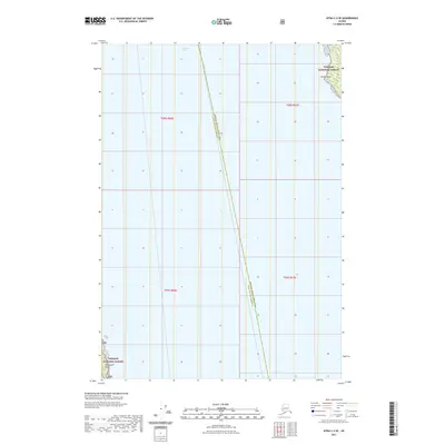
2021 Map of Sitka C-3 SE
USGS Topo · Published 2021About this map
Chatham Strait dominates this maritime survey, illustrating a critical waterway in Southeast Alaska. The map captures the boundary between the Hoonah-Angoon Census Area and the Sitka City and Borough, a line that bisects the open waters of the strait. On the eastern shore, the coast of Admiralty Island is defined by Parker Point within the Tongass National Forest, while the southwestern corner of the sheet includes the shoreline near Peninsula Point. The lack of inland infrastructure highlights the wilderness character of the Alexander Archipelago, where the landscape remains focused on the coastline and the vast protected lands of the Tongass. This modern survey provides a detailed look at the maritime geography and administrative divisions of the region just as it appeared in the early 2020s.
Find a feature on this map
9 named features on this map. Tap any name to fly to it.
Don’t see what you’re looking for? This feature index may not catch every label — zoom into the map to look around manually.
Map Details
Editions of this 2021 Sitka C-3 SE Map
This is the sole edition of this map. No revisions or reprints were ever made.
Other maps of this area

1948 · Sitka B-3
USGS Topo · 1:63,360

1948 · Sitka C-2
USGS Topo · 1:63,360

1948 · Sitka C-3
USGS Topo · 1:63,360

1948 · Sitka B-2
USGS Topo · 1:63,360

1951 · Sitka
USGS Topo · 1:250,000

1951 · Sitka B-3
USGS Topo · 1:63,360

1951 · Sitka B-2
USGS Topo · 1:63,360

1951 · Sitka C-3
USGS Topo · 1:63,360

1951 · Sitka C-2
USGS Topo · 1:63,360

1952 · Sitka
USGS Topo · 1:250,000