
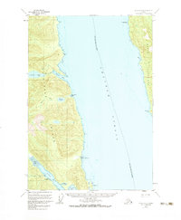
1951 Map of Sitka C-3
USGS Topo · Published 1974About this map
Chatham Strait divides the southeastern coastline of Chichagof Island from the western shores of Admiralty Island in this 1951 topographic study. The landscape is defined by deep inlets and freshwater systems, notably Kook Lake and Basket Lake, which drain through their respective creeks toward the strait. At Basket Bay, the hydrology of the interior island meets the saltwater, creating a sheltered cove just north of Little Basket Bay.
Find a feature on this map
20 named features on this map. Tap any name to fly to it.
Don’t see what you’re looking for? This feature index may not catch every label — zoom into the map to look around manually.
Map Details
Editions of this 1951 Sitka C-3 Map
2 editions found
Other maps of this area

1948 · Sitka B-3
USGS Topo · 1:63,360

1948 · Sitka C-2
USGS Topo · 1:63,360

1948 · Sitka C-3
USGS Topo · 1:63,360

1948 · Sitka D-3
USGS Topo · 1:63,360

1948 · Sitka D-2
USGS Topo · 1:63,360

1948 · Sitka D-4
USGS Topo · 1:63,360

1948 · Sitka B-2
USGS Topo · 1:63,360

1951 · Sitka B-4
USGS Topo · 1:63,360

1951 · Sitka C-4
USGS Topo · 1:63,360

1951 · Sitka
USGS Topo · 1:250,000