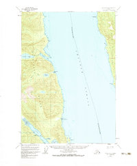
1951 Map of Sitka C-3
USGS Topo · Published 1983About this map
Chatham Strait serves as the dominant marine corridor of this maritime survey, separating the eastern shores of Chichagof Island from the western coastline of Admiralty Island. This stretch of the Alexander Archipelago is entirely contained within the Tongass National Forest, showing a landscape defined by deep inlets and freshwater systems. Notable hydrology includes Kook Lake and Basket Lake, which drain through the rugged interior toward the saltwater of Basket Bay. Further south, the map details the protected waters of Sitkoh Bay and Florence Bay. Coastal navigation features such as White Rock, Marble Bluffs, and Parker Pt provide essential landmarks for the City and Borough of Sitka, illustrating the intricate shoreline and tidal flats of the 1950s Tongass wilderness.
Find a feature on this map
18 named features on this map. Tap any name to fly to it.
Don’t see what you’re looking for? This feature index may not catch every label — zoom into the map to look around manually.
Map Details
Editions of this 1951 Sitka C-3 Map
2 editions found

Other maps of this area

1948 · Sitka B-3
USGS Topo · 1:63,360

1948 · Sitka C-2
USGS Topo · 1:63,360

1948 · Sitka C-3
USGS Topo · 1:63,360

1948 · Sitka D-3
USGS Topo · 1:63,360

1948 · Sitka D-2
USGS Topo · 1:63,360

1948 · Sitka D-4
USGS Topo · 1:63,360

1948 · Sitka B-2
USGS Topo · 1:63,360

1951 · Sitka B-4
USGS Topo · 1:63,360

1951 · Sitka C-4
USGS Topo · 1:63,360

1951 · Sitka
USGS Topo · 1:250,000