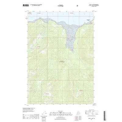
2017 Map of Sitka C-4 NW
USGS Topo · Published 2017About this map
Tongass National Forest dominates this coastal Alaska landscape, where the waters of Tenakee Inlet meet a network of industrial forest roads and glacial drainages. The map traces the critical intersection of water and timber infrastructure, notably through the Corner Bay Main Line and various spurs like Upper Fog Spur that reach into the steep drainages of Fog Creek and the Kadashan River. Along the northern shoreline, Crab Bay and the vicinity of Strawberry Island provide a clear view of the complex coastal geography and internal forest management blocks. This 2017 survey details the specific hydrography of the region, including Tonalite Cr and Hook Cr, documenting the modern-day trail and road networks used for resource access within the nation's largest national forest.
Find a feature on this map
20 named features on this map. Tap any name to fly to it.
Don’t see what you’re looking for? This feature index may not catch every label — zoom into the map to look around manually.
Map Details
Editions of this 2017 Sitka C-4 NW Map
This is the sole edition of this map. No revisions or reprints were ever made.
Other maps of this area

1948 · Sitka D-5
USGS Topo · 1:63,360

1948 · Sitka D-4
USGS Topo · 1:63,360

1951 · Sitka C-5
USGS Topo · 1:63,360

1951 · Sitka C-4
USGS Topo · 1:63,360

1951 · Sitka
USGS Topo · 1:250,000

1951 · Sitka D-5
USGS Topo · 1:63,360

1952 · Sitka
USGS Topo · 1:250,000

1955 · Sitka D-4
USGS Topo · 1:63,360

1964 · Sitka
USGS Topo · 1:250,000
1997 · Sitka D-4
USGS Topo · 1:63,360