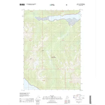
2017 Map of Sitka C-5 NE
USGS Topo · Published 2017About this map
Chichagof Island serves as the foundation for this 2017 topographic study, dominated by the expansive Tongass National Forest. The landscape is defined by the shoreline of Crab Bay to the north, where the tidal waters meet the densely forested interior. Moving inland, the terrain ascends toward Finger Mtn, illustrating the dramatic elevation changes characteristic of this portion of the Alexander Archipelago. This survey records the undeveloped character of the region during the early 21st century, showing no established roads or settlements within the quadrangle. The map is primarily a record of natural hydrology and forestry boundaries, providing a clear view of the wilderness before any modern infrastructure altered these specific coastal reaches.
Find a feature on this map
10 named features on this map. Tap any name to fly to it.
Don’t see what you’re looking for? This feature index may not catch every label — zoom into the map to look around manually.
Map Details
Editions of this 2017 Sitka C-5 NE Map
This is the sole edition of this map. No revisions or reprints were ever made.
Other maps of this area

1948 · Sitka D-5
USGS Topo · 1:63,360

1948 · Sitka D-4
USGS Topo · 1:63,360

1951 · Sitka C-5
USGS Topo · 1:63,360

1951 · Sitka C-4
USGS Topo · 1:63,360

1951 · Sitka
USGS Topo · 1:250,000

1951 · Sitka D-5
USGS Topo · 1:63,360

1952 · Sitka
USGS Topo · 1:250,000

1955 · Sitka D-4
USGS Topo · 1:63,360

1964 · Sitka
USGS Topo · 1:250,000
1997 · Sitka D-4
USGS Topo · 1:63,360