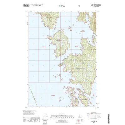
2017 Map of Sitka C-7 NW
USGS Topo · Published 2017About this map
Tongass National Forest blankets the intricate island chains and narrow waterways of the Alexander Archipelago on the outer coast of Chichagof Island. This survey highlights the complex maritime geography of the Gulf of Alaska shoreline, where deep inlets like Portlock Harbor and Didrickson Bay penetrate the land. Larger landmasses such as Hogan Island and Herbert Graves Island are separated by treacherous coastal waters including Imperial Passage and South Passage. The map documents the numerous hazards and landmarks essential for coastal navigation, such as the White Sisters and the Myriad Islands south of Kukkan Bay. Unlike interior regions, this landscape is defined almost entirely by its tidal reaches and rocky outcrops like Ittar Rock and Minnie Reef, providing a detailed view of the coastal wilderness within the Sitka Borough.
Find a feature on this map
37 named features on this map. Tap any name to fly to it.
Don’t see what you’re looking for? This feature index may not catch every label — zoom into the map to look around manually.
Map Details
Editions of this 2017 Sitka C-7 NW Map
This is the sole edition of this map. No revisions or reprints were ever made.
Other maps of this area

1948 · Sitka C-7
USGS Topo · 1:63,360

1948 · Sitka D-8
USGS Topo · 1:63,360

1950 · Sitka D-8
USGS Topo · 1:63,360

1951 · Sitka D-7
USGS Topo · 1:63,360

1951 · Sitka
USGS Topo · 1:250,000

1951 · Sitka C-7
USGS Topo · 1:63,360

1952 · Sitka
USGS Topo · 1:250,000

1964 · Sitka
USGS Topo · 1:250,000
1994 · Sitka C-7
USGS Topo · 1:63,360
1995 · Sitka D-8
USGS Topo · 1:63,360