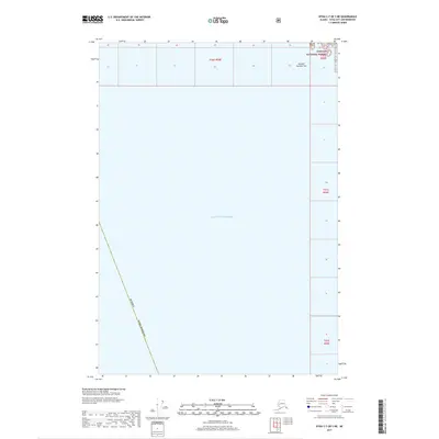
2017 Map of Sitka C-7 OE S NE
USGS Topo · Published 2017About this map
Alaska Sitka Borough boundaries meet the expansive waters of the Gulf of Alaska in this 2017 maritime and coastal survey. The map depicts a predominantly aquatic landscape along the southeastern Alaskan coast, punctuated only by a small terrestrial area in the northeastern corner within the Tongass National Forest. This section includes the named coastal feature Breaker Number Two, situated along the rugged shoreline where the Pacific swells reach the forest's edge. The layout emphasizes the vast maritime reaches of the region, providing a clear visualization of the political and natural boundaries that define the waters offshore from the Sitka area. It serves as a modern record of the intersection between federal forest lands and the open gulf.
Find a feature on this map
4 named features on this map. Tap any name to fly to it.
Don’t see what you’re looking for? This feature index may not catch every label — zoom into the map to look around manually.
Map Details
Editions of this 2017 Sitka C-7 OE S NE Map
This is the sole edition of this map. No revisions or reprints were ever made.
Other maps of this area

1948 · Sitka C-7
USGS Topo · 1:63,360

1948 · Sitka C-6
USGS Topo · 1:63,360

1951 · Sitka B-6
USGS Topo · 1:63,360

1951 · Sitka
USGS Topo · 1:250,000

1951 · Sitka C-6
USGS Topo · 1:63,360

1951 · Sitka C-7
USGS Topo · 1:63,360

1952 · Sitka
USGS Topo · 1:250,000

1964 · Sitka
USGS Topo · 1:250,000
1994 · Sitka C-7
USGS Topo · 1:63,360
1996 · Sitka B-6
USGS Topo · 1:63,360