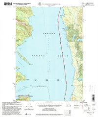
1997 Map of Sitka D-3
USGS Topo · Published 2000About this map
Chatham Strait serves as the central maritime artery of this coastal Alaskan landscape, separating the rugged shorelines of Chichagof Island to the west and Admiralty Island to the east. The map documents a wilderness transitioning between industrial activity and conservation, evidenced by the presence of a Logging Camp near Cube Cove and the site of Gypsum (Aband) on the Iyoukeen Peninsula.
Find a feature on this map
45 named features on this map. Tap any name to fly to it.
Don’t see what you’re looking for? This feature index may not catch every label — zoom into the map to look around manually.
Map Details
Editions of this 1997 Sitka D-3 Map
This is the sole edition of this map. No revisions or reprints were ever made.
Other maps of this area

1948 · Juneau A-3
USGS Topo · 1:63,360

1948 · Juneau A-4
USGS Topo · 1:63,360

1948 · Sitka C-2
USGS Topo · 1:63,360

1948 · Sitka C-3
USGS Topo · 1:63,360

1948 · Sitka D-3
USGS Topo · 1:63,360

1948 · Sitka D-2
USGS Topo · 1:63,360

1948 · Sitka D-4
USGS Topo · 1:63,360

1950 · Juneau A-3
USGS Topo · 1:63,360

1951 · Juneau
USGS Topo · 1:250,000

1951 · Juneau A-2
USGS Topo · 1:63,360