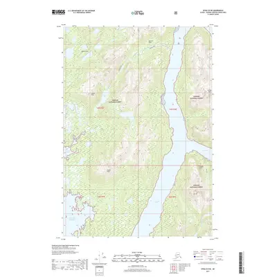
2017 Map of Sitka D-8 NE
USGS Topo · Published 2017About this map
Lisianski Strait carves a deep passage through this portion of the Alexander Archipelago, separating the eastern shores of Yakobi Island from the massive landmass of Chichagof Island. This coastal landscape within the Tongass National Forest is defined by steep glacial topography and complex marine inlets. To the west, the island interior rises sharply toward Takanis Peak and Yakobi Peak, with drainage systems feeding into Takanis Lake and the sheltered waters of Takanis Bay. On the Chichagof side, the terrain is equally formidable, marked by high points like El Nido Peak and Mt Hill. The maritime character of the region is underscored by numerous inlets including Squid Bay on the Gulf of Alaska and the protected reach of Stag Bay further east. Bohemia Basin sits in the north, showing the natural catchment areas and watercourses such as Bohemia Cr that shape this unpopulated wilderness.
Find a feature on this map
23 named features on this map. Tap any name to fly to it.
Don’t see what you’re looking for? This feature index may not catch every label — zoom into the map to look around manually.
Map Details
Editions of this 2017 Sitka D-8 NE Map
This is the sole edition of this map. No revisions or reprints were ever made.
Other maps of this area

1948 · Mount Fairweather A-2
USGS Topo · 1:63,360

1948 · Sitka D-8
USGS Topo · 1:63,360

1948 · Mount Fairweather A-1
USGS Topo · 1:63,360

1950 · Sitka D-8
USGS Topo · 1:63,360

1951 · Sitka D-7
USGS Topo · 1:63,360

1951 · Mt Fairweather
USGS Topo · 1:250,000

1951 · Sitka
USGS Topo · 1:250,000

1952 · Sitka
USGS Topo · 1:250,000

1954 · Mount Fairweather A-1
USGS Topo · 1:63,360

1961 · Mt Fairweather
USGS Topo · 1:250,000