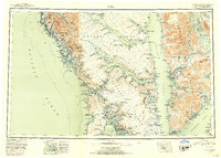
1952 Map of Sitka
USGS Topo · Published 1953About this map
Chichagof Island and Baranof Island dominate this mid-century reconnaissance of the Alexander Archipelago, showing a landscape defined by maritime industry and remote outposts. The coastal settlement of Sitka serves as the primary hub, surrounded by a complex network of waterways including Sitka Sound and the narrow Peril Strait. Commercial activity is evidenced by several remote sites such as the Dora Cannery Pt, a Logging Camp near Sunnyside, and the Cobol Mine on the western shore of Chichagof.
Find a feature on this map
188 named features on this map. Tap any name to fly to it.
Don’t see what you’re looking for? This feature index may not catch every label — zoom into the map to look around manually.
Map Details
Editions of this 1952 Sitka Map
4 editions found

Other maps of this area

1948 · Juneau A-3
USGS Topo · 1:63,360

1948 · Sitka B-3
USGS Topo · 1:63,360

1948 · Juneau A-4
USGS Topo · 1:63,360

1948 · Sitka D-1
USGS Topo · 1:63,360

1948 · Sitka B-1
USGS Topo · 1:63,360

1948 · Sitka A-5
USGS Topo · 1:63,360

1948 · Sitka A-3
USGS Topo · 1:63,360

1948 · Sitka C-7
USGS Topo · 1:63,360

1948 · Sitka C-2
USGS Topo · 1:63,360

1948 · Sitka A-2
USGS Topo · 1:63,360