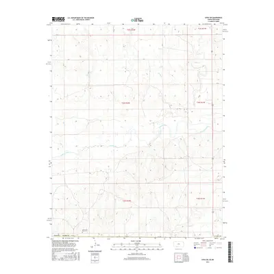
2016 Map of Sitka SW
USGS Topo · Published 2016About this map
The Cimarron River winds through the heart of this Clark County landscape, defining the hydrology of the southern Kansas plains. This 2016 survey documents a rural environment where large ranching operations and water management shape the land. Local history and genealogy interest is anchored by the Snake Creek Ranch Cem located in the southwestern portion of the quadrangle, serving as a quiet landmark of family lineage in the area. The terrain is further etched by several seasonal and permanent watercourses, including Snake Cr, Spring Cr, Day Cr, and Bear Cr, which converge toward the river valley. A grid of county roads, such as Co RD G G and CR Y, provides the primary network through the expansive townships of t34s r22w and t35s r21w, reflecting the enduring Public Land Survey System structure that organizes this agricultural and ranching territory.
Find a feature on this map
19 named features on this map. Tap any name to fly to it.
Don’t see what you’re looking for? This feature index may not catch every label — zoom into the map to look around manually.
Map Details
Editions of this 2016 Sitka SW Map
This is the sole edition of this map. No revisions or reprints were ever made.
Other maps of this area

1894 · Sitka
USGS Topo · 1:62,500

1896 · Ashland
USGS Topo · 1:125,000

1955 · Woodward
USGS Topo · 1:250,000

1955 · Pratt
USGS Topo · 1:250,000

1958 · Woodward
USGS Topo · 1:250,000

1959 · Pratt
USGS Topo · 1:250,000

1970 · Buffalo NW
USGS Topo · 1:24,000

1970 · Rosston NE
USGS Topo · 1:24,000

1970 · Buffalo NE
USGS Topo · 1:24,000
1972 · Ashland SE
USGS Topo · 1:24,000