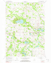
1964 Map of Six Lakes
USGS Topo · Published 1982About this map
The Six Lakes area at the border of Mecosta Co and Montcalm Co is defined by an intricate network of kettle lakes and glacial drainages. This landscape, surveyed in the early 1960s, reveals a community built around the Chesapeake and Ohio railroad corridor, which links the primary settlement at Six Lakes to the surrounding rural townships of Hinton, Millbrook, and Belvidere. The map details a transition between mid-century agriculture and growing recreational use, with many small lakes such as First Lake, Second Lake, and Townline Lake punctuated by numerous Gravel Pit operations that speak to the region's geological composition.
Find a feature on this map
51 named features on this map. Tap any name to fly to it.
Don’t see what you’re looking for? This feature index may not catch every label — zoom into the map to look around manually.
Map Details
Editions of this 1964 Six Lakes Map
2 editions found
Other maps of this area

1954 · Midland
USGS Topo · 1:250,000

1958 · Midland
USGS Topo · 1:250,000

1958 · Big Rapids
USGS Topo · 1:62,500

1959 · Midland
USGS Topo · 1:250,000

1959 · Howard City
USGS Topo · 1:62,500

1964 · Edmore
USGS Topo · 1:24,000

1964 · Six Lakes
USGS Topo · 1:24,000

1964 · Blanchard
USGS Topo · 1:24,000

1964 · Langston
USGS Topo · 1:24,000

1964 · Mecosta
USGS Topo · 1:24,000