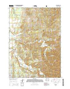
2014 Map of Sixes
USGS Topo · Published 2014About this map
The Sixes River and Elk River carve deep valleys through this coastal Oregon landscape, dominated by the heavily timbered reaches of the Siskiyou National Forest. The settlement of Sixes sits along the Oregon Coast Hwy, marking a point of transition between the low-lying coastal plains and the high peaks of the Coast Range. Inland, the topography rises sharply to Summit Mtn and Eightmile Prairie Mtn, while Poverty Ridge and Saddle Rock divide numerous drainage basins including Crystal Cr and Edson Cr. The industrial legacy of the region is evidenced by features like Marsh Log Pond, which reflects the importance of timber management near the coast. Near the southern map boundary, the terrain levels out around Garrison Lake and the outskirts of Port Orford, while Silver Butte provides a prominent landmark overlooking Silver Butte Cr.
Find a feature on this map
67 named features on this map. Tap any name to fly to it.
Don’t see what you’re looking for? This feature index may not catch every label — zoom into the map to look around manually.
Map Details
Editions of this 2014 Sixes Map
This is the sole edition of this map. No revisions or reprints were ever made.
Other maps of this area

1899 · Port Orford
USGS Topo · 1:125,000

1903 · Port Orford
USGS Topo · 1:125,000

1954 · Coos Bay
USGS Topo · 1:250,000

1954 · Port Orford
USGS Topo · 1:62,500

1954 · Cape Blanco
USGS Topo · 1:62,500

1954 · Langlois
USGS Topo · 1:62,500

1958 · Coos Bay
USGS Topo · 1:250,000

1962 · Coos Bay
USGS Topo · 1:250,000
1985 · Calf Ranch Mtn
USGS Topo · 1:24,000
1986 · Langlois
USGS Topo · 1:24,000