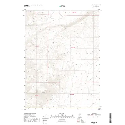
2021 Map of Sixmile Hill
USGS Topo · Published 2021About this map
Sixmile Hill dominates the southern landscape of this Elko County region, where the terrain transitions toward the sweeping expanse of Squaw Valley to the north. This 2021 survey illustrates a sparsely settled area of Nevada defined by subtle water sources and significant elevation changes. Drainage patterns are anchored by the seasonal flow of Sixmile Cr, while Rocky Canyon Spring provides a critical point of interest in the northwestern section of the quadrangle. The map clearly delineates the Public Land Survey System grid across multiple townships, including t37n r45e and t37n r46e, offering a precise look at how the land is partitioned in this high-desert environment. For those tracing the geography of the Great Basin, the map preserves the relationship between these remote named landmarks and the surrounding drainage basins.
Find a feature on this map
11 named features on this map. Tap any name to fly to it.
Don’t see what you’re looking for? This feature index may not catch every label — zoom into the map to look around manually.
Map Details
Editions of this 2021 Sixmile Hill Map
This is the sole edition of this map. No revisions or reprints were ever made.
Other maps of this area

1955 · McDermitt
USGS Topo · 1:250,000

1955 · Winnemucca
USGS Topo · 1:250,000

1958 · Winnemucca
USGS Topo · 1:250,000

1959 · McDermitt
USGS Topo · 1:250,000

1962 · Winnemucca
USGS Topo · 1:250,000

1965 · Izzenhood Gap
USGS Topo · 1:24,000

1965 · Sixmile Hill
USGS Topo · 1:24,000
1965 · Jake Creek Mtn
USGS Topo · 1:24,000

1965 · Sheep Creek Range NW
USGS Topo · 1:24,000

1965 · Squaw Valley Ranch
USGS Topo · 1:24,000