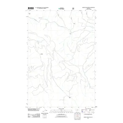
2011 Map of Sixmile Mountain
USGS Topo · Published 2011About this map
Sixmile Mountain dominates this Gallatin County landscape, serving as a high-elevation centerpiece for a complex network of seasonal drainages and rangeland. The 2011 survey documents a remote area defined by livestock operations and logging history, as evidenced by Koenig Ranch, Daniels Cow Camp, and the lower reaches of Sawmill Gulch. The hydrology of the area is characterized by ephemeral flows including Dry Creek, which is paralleled by Dry Creek Rd, and several distinct gulches such as Miners Gulch and Meyers Gulch. These features, along with Sixmile Creek and Paddys Run, illustrate the intricate drainage patterns of the Montana backcountry. The road system is limited to primitive routes like Ridge Rd and Shaw Rd, reflecting the high-altitude, unpopulated nature of the terrain during the early 21st century.
Find a feature on this map
13 named features on this map. Tap any name to fly to it.
Don’t see what you’re looking for? This feature index may not catch every label — zoom into the map to look around manually.
Map Details
Editions of this 2011 Sixmile Mountain Map
This is the sole edition of this map. No revisions or reprints were ever made.
Other maps of this area

1886 · Fort Logan
USGS Topo · 1:250,000

1948 · White Sulphur Springs
USGS Topo · 1:250,000

1949 · Maudlow
USGS Topo · 1:62,500

1949 · Toston
USGS Topo · 1:62,500

1950 · Duck Creek Pass
USGS Topo · 1:62,500

1958 · White Sulphur Springs
USGS Topo · 1:250,000

1961 · White Sulphur Springs
USGS Topo · 1:250,000

1965 · White Sulphur Springs
USGS Topo · 1:250,000
1971 · Battle Mountain
USGS Topo · 1:24,000
1971 · Sulphur Bar Creek
USGS Topo · 1:24,000