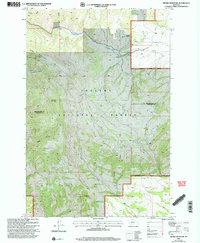
2001 Map of Sixmile Mountain
USGS Topo · Published 2004About this map
Helena National Forest dominates this landscape, where the high terrain of Sixmile Mountain gives way to a network of steep drainages and isolated outposts. Mapping of the area reveals the persistence of high-country ranching and forestry operations through sites like Koenig Ranch and Daniels Cow Camp. The map documents a rugged interior divided by the Broadwater and Gallatin County line, tracing historical water sources and routes such as Sixmile Creek and the deep cuts of Rocky Canyon.
Find a feature on this map
17 named features on this map. Tap any name to fly to it.
Don’t see what you’re looking for? This feature index may not catch every label — zoom into the map to look around manually.
Map Details
Editions of this 2001 Sixmile Mountain Map
This is the sole edition of this map. No revisions or reprints were ever made.
Other maps of this area

1886 · Fort Logan
USGS Topo · 1:250,000

1948 · White Sulphur Springs
USGS Topo · 1:250,000

1949 · Maudlow
USGS Topo · 1:62,500

1949 · Toston
USGS Topo · 1:62,500

1950 · Duck Creek Pass
USGS Topo · 1:62,500

1958 · White Sulphur Springs
USGS Topo · 1:250,000

1961 · White Sulphur Springs
USGS Topo · 1:250,000

1965 · White Sulphur Springs
USGS Topo · 1:250,000
1971 · Battle Mountain
USGS Topo · 1:24,000
1971 · Sulphur Bar Creek
USGS Topo · 1:24,000