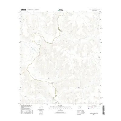
2016 Map of Sixshooter Canyon
USGS Topo · Published 2016About this map
The Pecos River carves a deep, winding course through this West Texas landscape, marking the boundary between Crockett and Terrell Counties. This high-desert terrain is defined by a network of significant draws and steep-walled canyons, including the prominent Sixshooter Canyon, Big Canyon, and Sulfur Canyon. The hydrological patterns of the region are punctuated by reliable water sources like Independence Cr, which joins the main river channel, alongside isolated points of interest such as Wolf Spring and Richland Spring. These springs and seasonal drainages were historically critical for livestock and navigation in an otherwise arid environment. While largely devoid of major settlements, the map documents the essential rural infrastructure of the mid-2010s, including Richland Springs Rd and Co Rd 410, which provide access to the remote draws and ranch lands surrounding Richland Canyon.
Find a feature on this map
13 named features on this map. Tap any name to fly to it.
Don’t see what you’re looking for? This feature index may not catch every label — zoom into the map to look around manually.
Map Details
Editions of this 2016 Sixshooter Canyon Map
This is the sole edition of this map. No revisions or reprints were ever made.
Other maps of this area

1929 · Sheffield
USGS Topo · 1:125,000

1954 · Sonora
USGS Topo · 1:250,000

1958 · Sonora
USGS Topo · 1:250,000

1967 · Burnt Canyon
USGS Topo · 1:24,000

1967 · Sheffield SE
USGS Topo · 1:24,000

1967 · Dead Man Canyon
USGS Topo · 1:24,000

1970 · Antone Canyon
USGS Topo · 1:24,000
1970 · Prince Albert Draw
USGS Topo · 1:24,000

1973 · Post Canyon
USGS Topo · 1:24,000
1973 · Sixshooter Canyon
USGS Topo · 1:24,000