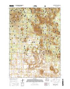
2017 Map of Sixteen Butte
USGS Topo · Published 2017About this map
Sixteen Butte stands as a central landmark in this high-desert landscape within the Deschutes National Forest. The 2017 terrain is defined by a series of volcanic features, including Poly Top Butte, Rogers Butte, and the distinctive Horseshoe Butte. In the southern portion of the quadrangle, the lava-strewn expanse of The Devils Garden provides a stark contrast to the timbered slopes found elsewhere in the forest. The map documents a complex network of forest access including Natl Forest Develop Road 23 Rd and specialized routes like Ohv #90, reflecting the modern management of this public land for both transit and recreation. The boundary between Deschutes and Lake Counties cuts across the northern peaks, marking the jurisdictional divide in this high-elevation wilderness.
Find a feature on this map
26 named features on this map. Tap any name to fly to it.
Don’t see what you’re looking for? This feature index may not catch every label — zoom into the map to look around manually.
Map Details
Editions of this 2017 Sixteen Butte Map
This is the sole edition of this map. No revisions or reprints were ever made.
Other maps of this area

1931 · Newberry Crater
USGS Topo · 1:125,000

1935 · Newberry Crater
USGS Topo · 1:125,000

1955 · Crescent
USGS Topo · 1:250,000

1957 · Crescent
USGS Topo · 1:250,000

1958 · Crescent
USGS Topo · 1:250,000

1970 · Crescent
USGS Topo · 1:250,000

1979 · Crescent
USGS Topo · 1:100,000

1981 · Fox Butte
USGS Topo · 1:24,000

1981 · Hogback Butte
USGS Topo · 1:24,000

1981 · Cougar Mtn
USGS Topo · 1:24,000