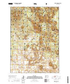
2020 Map of Sixteen Butte
USGS Topo · Published 2020About this map
Deschutes National Forest lands dominate this high-desert landscape in central Oregon, where a series of volcanic peaks rise sharply above the surrounding flats. The topographical character is defined by named cinder cones and formations including Sixteen Butte, Deadlog Butte, and the distinctive Horseshoe Butte. These landmarks provide critical navigation points in a region marked by sparse vegetation and rugged natural contours.
Find a feature on this map
21 named features on this map. Tap any name to fly to it.
Don’t see what you’re looking for? This feature index may not catch every label — zoom into the map to look around manually.
Map Details
Editions of this 2020 Sixteen Butte Map
This is the sole edition of this map. No revisions or reprints were ever made.
Other maps of this area

1931 · Newberry Crater
USGS Topo · 1:125,000

1935 · Newberry Crater
USGS Topo · 1:125,000

1955 · Crescent
USGS Topo · 1:250,000

1957 · Crescent
USGS Topo · 1:250,000

1958 · Crescent
USGS Topo · 1:250,000

1970 · Crescent
USGS Topo · 1:250,000

1979 · Crescent
USGS Topo · 1:100,000

1981 · Fox Butte
USGS Topo · 1:24,000

1981 · Hogback Butte
USGS Topo · 1:24,000

1981 · Cougar Mtn
USGS Topo · 1:24,000