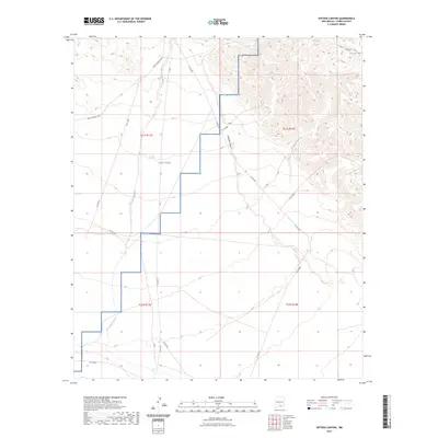
2023 Map of Sixteen Canyon
USGS Topo · Published 2023About this map
Fort Bliss military reservation lands dominate the central landscape of this Otero County region, where the high desert terrain transitions from the steep ridges near Chatfield Canyon to the drainage of the Sacramento River. The map provides a detailed look at the modern rural infrastructure, defined by a network of county roads including Co Rd E001 and Co Rd F049 that crisscross the arid basins. Water management is a critical feature of this environment, evidenced by isolated landmarks such as Munson Tank in the northeast. The primary transit artery, the Owen Prather Hwy, cuts across the northern sections, connecting the remote canyon country with the broader regional road network. This survey reflects the intersection of federal military land use and local ranching accessibility in the southern New Mexico desert.
Find a feature on this map
22 named features on this map. Tap any name to fly to it.
Don’t see what you’re looking for? This feature index may not catch every label — zoom into the map to look around manually.
Map Details
Editions of this 2023 Sixteen Canyon Map
This is the sole edition of this map. No revisions or reprints were ever made.
Other maps of this area

1954 · Carlsbad
USGS Topo · 1:250,000

1958 · Carlsbad
USGS Topo · 1:250,000

1963 · Indian Draw
USGS Topo · 1:24,000

1963 · Cleones Tank
USGS Topo · 1:24,000

1965 · Surveyors Canyon
USGS Topo · 1:24,000

1965 · El Paso Canyon
USGS Topo · 1:24,000

1965 · Pinon
USGS Topo · 1:24,000

1979 · Alamogordo
USGS Topo · 1:100,000

1979 · Crow Flats
USGS Topo · 1:100,000
1980 · El Paso Draw
USGS Topo · 1:24,000