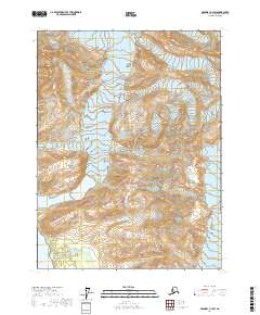
2017 Map of Skagway A-3 SW
USGS Topo · Published 2017About this map
Glacier Bay National Park dominates this terrain in the Hoonah-Angoon Census Area, where glacial processes continue to shape the coastal landscape. The movement of the McBride Glacier and its relationship to the waters of Muir Inlet are clearly visible, providing a baseline for researchers tracking the transformation of this environment. High-elevation landmarks such as Black Mtn and Coleman Peak rise above the surrounding ice and rock, while the structured lines of McConnell Ridge and Van Horn Ridge define the vertical relief of the region. This survey captures the intersection of monumental peaks and receding ice fields, reflecting the dynamic physical geography of the Alaskan wilderness as documented in the early 21st century.
Find a feature on this map
11 named features on this map. Tap any name to fly to it.
Don’t see what you’re looking for? This feature index may not catch every label — zoom into the map to look around manually.
Map Details
Editions of this 2017 Skagway A-3 SW Map
This is the sole edition of this map. No revisions or reprints were ever made.
Other maps of this area

1948 · Mount Fairweather D-1
USGS Topo · 1:63,360

1949 · Juneau D-6
USGS Topo · 1:63,360

1951 · Juneau
USGS Topo · 1:250,000

1951 · Mt Fairweather
USGS Topo · 1:250,000

1952 · Skagway
USGS Topo · 1:250,000

1954 · Mount Fairweather D-1
USGS Topo · 1:63,360

1954 · Skagway A-3
USGS Topo · 1:63,360
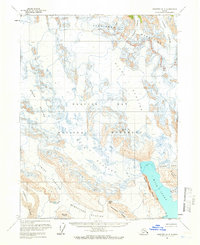
1961 · Skagway A-4
USGS Topo · 1:63,360

1961 · Mt Fairweather
USGS Topo · 1:250,000

1961 · Skagway
USGS Topo · 1:250,000