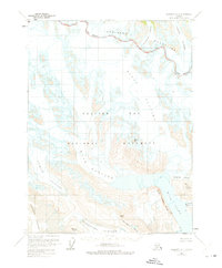
1961 Map of Skagway A-4
USGS Topo · Published 1975About this map
Glacier Bay National Monument dominates this mid-century topographic survey, revealing a landscape defined by retreating ice and emerging landforms. The immense Muir Glacier is shown in its 1960s state, feeding into the northern reaches of Muir Inlet. This document captures a period of significant glacial recession, where features like McBride Glacier and the Riggs Glacier were undergoing visible changes, leaving behind scoured terrain such as White Thunder Ridge and McConnell Ridge. To the north, the Takhinsha Mountains and Le Blondeau Glacier border the Haines Borough line, marking the transition from high alpine ice fields to the deep fjords below. Notable landmarks for navigation and study include Mount Brock, Glacier Pass, and the Bruce Hills, providing a detailed look at the geomorphology of Southeast Alaska before more modern shifts in the ice front.
Find a feature on this map
17 named features on this map. Tap any name to fly to it.
Don’t see what you’re looking for? This feature index may not catch every label — zoom into the map to look around manually.
Map Details
Editions of this 1961 Skagway A-4 Map
2 editions found
Other maps of this area

1948 · Mount Fairweather D-1
USGS Topo · 1:63,360

1948 · Mount Fairweather D-2
USGS Topo · 1:63,360

1950 · Mount Fairweather D-2
USGS Topo · 1:63,360

1951 · Mt Fairweather
USGS Topo · 1:250,000

1952 · Skagway
USGS Topo · 1:250,000

1954 · Mount Fairweather D-1
USGS Topo · 1:63,360

1954 · Skagway A-3
USGS Topo · 1:63,360

1954 · Skagway B-3
USGS Topo · 1:63,360

1954 · Skagway B-4
USGS Topo · 1:63,360
1961 · Skagway A-4
USGS Topo · 1:63,360