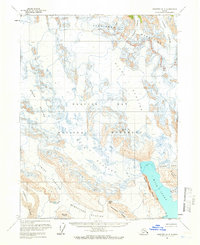
1961 Map of Skagway A-4
USGS Topo · Published 1961About this map
Glacier Bay National Monument dominates this mid-century survey, revealing a landscape defined by massive ice fields and evolving maritime geography. Extensive glaciological detail highlights the convergence of the Muir Glacier and Riggs Glacier as they flow toward Muir Inlet. This 1961 record provides significant information-gain regarding the historic recession of the ice, particularly at McBride Glacier, where blue-ticked lines indicate approximate limits of the Muir Glacier's retreat in earlier years. The terrain is framed by the high peaks of the Takhinsha Mountains to the north and the Bruce Hills to the south. Other prominent features include Cushing Glacier, Burroughs Glacier, and White Thunder Ridge, documenting a wilderness before modern recreational infrastructure, where no roads or trails existed on the rugged peninsula.
Find a feature on this map
19 named features on this map. Tap any name to fly to it.
Don’t see what you’re looking for? This feature index may not catch every label — zoom into the map to look around manually.
Map Details
Editions of this 1961 Skagway A-4 Map
2 editions found
Other maps of this area

1948 · Mount Fairweather D-1
USGS Topo · 1:63,360

1948 · Mount Fairweather D-2
USGS Topo · 1:63,360

1950 · Mount Fairweather D-2
USGS Topo · 1:63,360

1951 · Mt Fairweather
USGS Topo · 1:250,000

1952 · Skagway
USGS Topo · 1:250,000

1954 · Mount Fairweather D-1
USGS Topo · 1:63,360

1954 · Skagway A-3
USGS Topo · 1:63,360

1954 · Skagway B-3
USGS Topo · 1:63,360

1954 · Skagway B-4
USGS Topo · 1:63,360
1961 · Skagway A-5
USGS Topo · 1:63,360