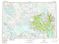
1961 Map of Skagway
USGS Topo · Published 1982About this map
Skagway and the northern reaches of the Lynn Canal form the industrial and transit heart of this southeastern Alaska region during the mid-twentieth century. The map documents the critical transportation corridors that defined the era, from the narrow-gauge White Pass & Yukon Route climbing toward the Canadian border to the Haines Highway following the path of the Chilkat River. In the west, the massive ice fields of Glacier Bay National Park dominate the landscape, with the Grand Pacific Glacier and Margerie Glacier showing the complex patterns of glacial movement recorded during the survey period.
Find a feature on this map
58 named features on this map. Tap any name to fly to it.
Don’t see what you’re looking for? This feature index may not catch every label — zoom into the map to look around manually.
Map Details
Editions of this 1961 Skagway Map
4 editions found

Other maps of this area

1948 · Skagway C-4
USGS Topo · 1:63,360

1948 · Skagway C-3
USGS Topo · 1:63,360

1948 · Mount Fairweather D-1
USGS Topo · 1:63,360

1948 · Juneau D-3
USGS Topo · 1:63,360

1948 · Skagway C-2
USGS Topo · 1:63,360

1948 · Skagway A-1
USGS Topo · 1:63,360

1948 · Mount Fairweather D-2
USGS Topo · 1:63,360

1948 · Skagway C-1
USGS Topo · 1:63,360

1949 · Atlin
USGS Topo · 1:250,000

1949 · Juneau D-6
USGS Topo · 1:63,360