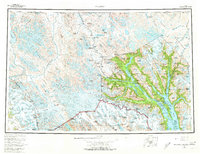
1961 Map of Skagway
USGS Topo · Published 1974About this map
Skagway and Haines serve as the primary coastal gateways in this mid-century survey of the northern Panhandle and the rugged Coast Mountains. The map provides a detailed view of the corridor between Taiya Inlet and the Chilkoot Trail, a route made famous during the gold rush era. To the west, the expansive Glacier Bay National Monument dominates the landscape, defined by deep fjords like Muir Inlet and Tarr Inlet.
Find a feature on this map
85 named features on this map. Tap any name to fly to it.
Don’t see what you’re looking for? This feature index may not catch every label — zoom into the map to look around manually.
Map Details
Editions of this 1961 Skagway Map
4 editions found

Other maps of this area

1948 · Skagway C-4
USGS Topo · 1:63,360

1948 · Skagway C-3
USGS Topo · 1:63,360

1948 · Mount Fairweather D-1
USGS Topo · 1:63,360

1948 · Juneau D-3
USGS Topo · 1:63,360

1948 · Skagway C-2
USGS Topo · 1:63,360

1948 · Skagway A-1
USGS Topo · 1:63,360

1948 · Mount Fairweather D-2
USGS Topo · 1:63,360

1948 · Skagway C-1
USGS Topo · 1:63,360

1949 · Atlin
USGS Topo · 1:250,000

1949 · Juneau D-6
USGS Topo · 1:63,360