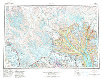
1961 Map of Skagway
USGS Topo · Published 1993About this map
Skagway and the surrounding wilderness of the Saint Elias Mountains are the focal points of this mid-century topographic record. The landscape is defined by the deep glacial fjords of Taiya Inlet and Lynn Canal, where maritime traffic once fueled the rush to the interior. The industrial and transportation legacy of the region is clearly visible, featuring the White Pass and Yukon RR winding north into the Coast Mountains and an Historical Trail climbing past Dyea. This edition captures the boundaries of Klondike Gold Rush Nat Hist Park and the expansive Glacier Bay National Park and Wilderness, reflecting the transition from an extractive economy to one centered on preservation. Smaller settlements like Klukwan and Haines sit near the confluence of the Chilkat River and Tsirku River, highlighting the vital role of river valleys in navigating this formidable terrain.
Find a feature on this map
127 named features on this map. Tap any name to fly to it.
Don’t see what you’re looking for? This feature index may not catch every label — zoom into the map to look around manually.
Map Details
Editions of this 1961 Skagway Map
4 editions found

Other maps of this area

1948 · Skagway C-4
USGS Topo · 1:63,360

1948 · Skagway C-3
USGS Topo · 1:63,360

1948 · Mount Fairweather D-1
USGS Topo · 1:63,360

1948 · Juneau D-3
USGS Topo · 1:63,360

1948 · Skagway C-2
USGS Topo · 1:63,360

1948 · Skagway A-1
USGS Topo · 1:63,360

1948 · Mount Fairweather D-2
USGS Topo · 1:63,360

1948 · Skagway C-1
USGS Topo · 1:63,360

1949 · Atlin
USGS Topo · 1:250,000

1949 · Juneau D-6
USGS Topo · 1:63,360