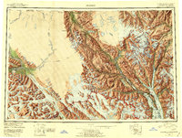
1952 Map of Skagway
USGS Topo · Published 1956About this map
The White Pass & Yukon Route railroad snakes through the mountains toward the Canadian border, anchoring the transport network of this 1950s reconnaissance. Skagway and Haines serve as the primary coastal gateways, connected by the deep waters of Chilkoot Inlet and Chilkat Inlet. Further inland, the map captures the transition from tidal waters to the massive ice fields of Glacier Bay National Monument, including the Muir Glacier and Grand Pacific Glacier. Settlement patterns are concentrated along the river valleys and highways, with Klukwan and Wells situated along the Chilkat River, while the Haines Highway provides a critical overland link. This era of mapping reflects a landscape defined by its glacial hydrology, where the Alsek River and Tatshenshini River carve through the St. Elias Mountains, and remote outposts like Pleasant Camp and Bear Camp mark the limits of the early road network.
Find a feature on this map
96 named features on this map. Tap any name to fly to it.
Don’t see what you’re looking for? This feature index may not catch every label — zoom into the map to look around manually.
Map Details
Editions of this 1952 Skagway Map
4 editions found

Other maps of this area

1948 · Skagway C-4
USGS Topo · 1:63,360

1948 · Skagway C-3
USGS Topo · 1:63,360

1948 · Mount Fairweather D-1
USGS Topo · 1:63,360

1948 · Juneau D-3
USGS Topo · 1:63,360

1948 · Skagway C-2
USGS Topo · 1:63,360

1948 · Skagway A-1
USGS Topo · 1:63,360

1948 · Mount Fairweather D-2
USGS Topo · 1:63,360

1948 · Skagway C-1
USGS Topo · 1:63,360

1949 · Atlin
USGS Topo · 1:250,000

1949 · Juneau D-6
USGS Topo · 1:63,360